Cape Naturaliste facts for kids
Quick facts for kids Cape NaturalisteWestern Australia |
|
|---|---|

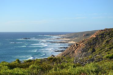
Picture of Cape Naturaliste, WA
|
Cape Naturaliste is a cape (a piece of land that sticks out into the sea) located in the southwest part of Western Australia. It sits on the western edge of Geographe Bay. This cape is the most northern point of the Leeuwin-Naturaliste Ridge, a long line of hills and land that was named after the cape itself. Many other important places and features in the area also get their names from Cape Naturaliste, like the Leeuwin-Naturaliste National Park, the Cape Naturaliste Lighthouse, and the popular Cape to Cape hiking trail.
Nearby Towns
The closest community to Cape Naturaliste is Bunker Bay. This area started as simple holiday homes but has grown into a place with fancy houses and a well-known beach resort. A bit further east, across the bay, you'll find Dunsborough, which is an older and more established town. Even further east from Dunsborough is the larger city of Busselton.
History of the Cape
The very first people to live around Cape Naturaliste were the Wardandi Aboriginals. They had a special name for the cape: "Kwirreejeenungup," which means "the place with the beautiful view."
In 1801, a French explorer named Nicolas Baudin visited the cape on May 30th. He was on a big trip to explore and map the coast of Australia, which was then known as New Holland. Baudin named the large bay he found "Geographe Bay," after his main ship, the Géographe. Later, the cape itself was named after his second ship, the Naturaliste.
Weather at Cape Naturaliste
Cape Naturaliste has a Mediterranean climate. This means it has warm, dry summers and mild, wet winters. It's a bit like the weather you might find in places around the Mediterranean Sea.
| Climate data for Cape Naturaliste (33º32'S, 115º01'E, 109 m AMSL) (1903-2024 normals and extremes) | |||||||||||||
|---|---|---|---|---|---|---|---|---|---|---|---|---|---|
| Month | Jan | Feb | Mar | Apr | May | Jun | Jul | Aug | Sep | Oct | Nov | Dec | Year |
| Record high °C (°F) | 40.6 (105.1) |
39.4 (102.9) |
37.4 (99.3) |
32.1 (89.8) |
27.8 (82.0) |
24.3 (75.7) |
22.9 (73.2) |
23.6 (74.5) |
27.5 (81.5) |
31.7 (89.1) |
36.7 (98.1) |
38.5 (101.3) |
40.6 (105.1) |
| Mean daily maximum °C (°F) | 25.6 (78.1) |
26.0 (78.8) |
24.6 (76.3) |
22.0 (71.6) |
19.3 (66.7) |
17.4 (63.3) |
16.4 (61.5) |
16.5 (61.7) |
17.4 (63.3) |
19.0 (66.2) |
21.6 (70.9) |
23.8 (74.8) |
20.8 (69.4) |
| Mean daily minimum °C (°F) | 15.3 (59.5) |
15.7 (60.3) |
15.1 (59.2) |
13.9 (57.0) |
12.6 (54.7) |
11.5 (52.7) |
10.5 (50.9) |
10.1 (50.2) |
10.4 (50.7) |
11.1 (52.0) |
12.5 (54.5) |
14.0 (57.2) |
12.7 (54.9) |
| Record low °C (°F) | 7.8 (46.0) |
8.9 (48.0) |
6.4 (43.5) |
5.1 (41.2) |
6.1 (43.0) |
4.2 (39.6) |
4.1 (39.4) |
3.7 (38.7) |
3.8 (38.8) |
4.6 (40.3) |
5.2 (41.4) |
7.5 (45.5) |
3.7 (38.7) |
| Average precipitation mm (inches) | 10.6 (0.42) |
11.7 (0.46) |
22.9 (0.90) |
44.2 (1.74) |
113.6 (4.47) |
160.2 (6.31) |
158.8 (6.25) |
112.2 (4.42) |
75.1 (2.96) |
48.6 (1.91) |
25.4 (1.00) |
13.1 (0.52) |
793.6 (31.24) |
| Average precipitation days (≥ 1.0 mm) | 1.9 | 1.9 | 3.2 | 6.6 | 12.9 | 16.7 | 18.8 | 16.4 | 12.6 | 8.9 | 5.0 | 2.7 | 107.6 |
| Average afternoon relative humidity (%) | 57 | 56 | 58 | 62 | 69 | 72 | 72 | 70 | 68 | 65 | 61 | 59 | 64 |
| Average dew point °C (°F) | 14.1 (57.4) |
14.4 (57.9) |
13.6 (56.5) |
12.7 (54.9) |
11.8 (53.2) |
10.8 (51.4) |
9.8 (49.6) |
9.5 (49.1) |
9.9 (49.8) |
10.6 (51.1) |
11.9 (53.4) |
13.0 (55.4) |
11.8 (53.3) |
| Source: Bureau of Meteorology | |||||||||||||

