
Cape Petersen facts for kids

Cape Petersen is a rounded, ice-covered piece of land found on the northern side of Thurston Island in Antarctica. It's about 18 nautical miles (which is about 33 kilometers) east-northeast of another place called Cape Flying Fish. This cape is an important landmark in the icy landscape of Antarctica.
Discovering Cape Petersen
Cape Petersen was first mapped and described using aerial photographs. These pictures were taken during a special mission by the United States Navy in December 1946. This mission was called U.S. Navy Operation Highjump. It was a large expedition that explored and mapped much of Antarctica from the air.
How Cape Petersen Got Its Name
The name "Cape Petersen" was given by the Advisory Committee on Antarctic Names (US-ACAN). This committee is responsible for naming features in Antarctica for the United States. They named the cape after Carl O. Petersen.
Carl O. Petersen was a radio engineer. He was part of the famous Byrd Antarctic Expedition. This expedition explored Antarctica in the late 1920s and early 1930s. Petersen helped with communications during the expeditions in 1928-30 and again in 1933–35.
Images for kids
-
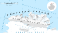
Map of Thurston Island.
-
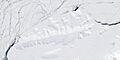
Satellite image of Thurston Island.


