Captain, Virginia facts for kids
Quick facts for kids
Captain, Virginia
|
|
|---|---|

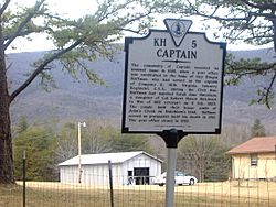
Historical marker in Captain, detailing the history of the town name
|
|
| Country | United States |
| State | Virginia |
| County | Craig |
| Elevation | 2,037 ft (621 m) |
| Time zone | UTC-5 (Eastern (EST)) |
| • Summer (DST) | UTC-4 (EDT) |
| ZIP code |
24127
|
| Area code | 540 |
| GNIS ID | 1482318 |
Captain is a small, unincorporated community located in the western part of Craig County, Virginia, in the United States. It is found where Johns Creek Road and Rocky Gap Trail meet.
Contents
About Captain, Virginia
Captain is a quiet place in the beautiful state of Virginia. It's known as an unincorporated community. This means it doesn't have its own local government like a city or town. Instead, it is governed by the larger Craig County.
What is an Unincorporated Community?
An unincorporated community is a place where people live together. However, it is not officially organized as a city or town. It doesn't have its own mayor or town council. Services like roads and schools are managed by the county government.
Where is Captain Located?
Captain is nestled in the western part of Craig County. This county is in the southwestern region of Virginia. The community sits at the meeting point of two local roads. These are Johns Creek Road and Rocky Gap Trail.
Quick Facts
Captain is located in a scenic area of Virginia. It has some interesting facts about its geography and services.
Elevation and Time Zone
Captain is quite high up! Its elevation is about 2,037 feet (621 meters) above sea level. This means it's located in a hilly or mountainous area. The community observes the Eastern Time Zone. This is the same time zone as many major cities on the East Coast.
Postal Information
If you wanted to send a letter to Captain, you would use the ZIP code 24127. The local telephone area code for Captain is 540.
 | Audre Lorde |
 | John Berry Meachum |
 | Ferdinand Lee Barnett |


