
Carleton Castle facts for kids
Quick facts for kids Carleton Castle |
|
|---|---|
| Lendalfoot, South Ayrshire, Scotland UK |
|

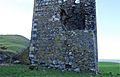
Remnants of the castle's keep
|
|

Carleton Castle
|
|
| Coordinates | 55°09′53″N 4°55′57″W / 55.1647°N 4.9325°W |
| Type | A tower castle and barmakin |
| Site information | |
| Owner | Little Carleton Farm |
| Open to the public |
No |
| Condition | A ruin |
| Site history | |
| Built | 15th century |
| Built by | Cathcarts of Killochan |
| In use | 15th to early 18th century |
| Materials | Stone |
Carleton Castle is an old castle ruin in Scotland. It was built a long time ago, in the 1400s. This historic place stands high above a village called Lendalfoot. The village is near the coast in South Ayrshire, Scotland. The castle is about 6 miles (9.7 km) south of Girvan.
Contents
Exploring Carleton Castle

Carleton Castle is a very old building from the 1400s. It was once owned by a powerful family called the Cathcarts of Killochan. The castle stands overlooking the village, close to some cliffs.
The castle was a tall, five-story tower. Today, it is mostly ruins. Part of a wall has fallen down, but it was partly rebuilt later. This suggests the tower might have been used as a house or storage building after it was a castle.
Behind the tower, there are also some old ruins that look like pigsties. These buildings even had roofs in the 1800s. The tower itself was quite small. It had only one private room. You could reach this room from a window in the main hall.
The main entrance to the tower was on the first floor. People likely used a wooden ladder or stairs to get in. The wall at the entrance was very thick, about 6 feet (1.8 meters) wide. It might have had stairs inside to reach the cellar and the great hall.
In one corner, a spiral staircase connected the hall to the cellar. A cool feature on the side facing the farm is a garderobe. This was like an old toilet chute that dropped waste outside the castle walls.
The Castle Courtyard
The castle also had a barmakin, which was a walled courtyard. This courtyard had towers at its corners. It was built between two deep, narrow valleys made by small streams.
The castle was important for guarding a mountain pass. It also controlled an old road that went to Portpatrick. This road used to run along the high ground nearby.
The tower had two vaulted ceilings. One was over the great hall, and the other was over the ground floor. Old pictures from the 1800s show that more of the great hall's vaulted ceiling was still there back then. Red sandstone was used to decorate the upper vault and window arches.
Carleton Castle on Old Maps

Old maps help us learn about the castle. A map from the 1660s by Blaeu shows the castle still standing. It also shows a fence or "pale" on the side of the castle not protected by the valleys.
This map also shows a "Karltoun Mill" and "Mains." These were likely connected to the Cathcarts, who owned the land. The "mains farm" usually provided food for the laird (the lord), his family, and servants.
Another map from 1685 by John Adair also shows the castle. Herman Moll's map from 1745 calls it "Karleton" and shows the old inland road to Portpatrick passing close by.
By 1775, a map by Taylor and Skinner clearly shows Carleton Castle as a ruin. However, it was still owned by a Cathcart baronet (a type of noble). Carleton Castle is similar to other castles in the Carrick area, like Dinvin and Dow Hill. The Cathcarts also owned other castles, such as Little Rigend.
The Little Carleton Motte
Across from Little Carleton Farm, there is a large earth mound. It is about 5 meters (16 feet) high and 20 meters (66 feet) wide. This mound is known as the Little Carleton Fort or Motte. It has a circular ditch around it.
This motte was built centuries before the stone castle. It was also owned by the Cathcarts. Because it was so close to the castle, the motte might have been a "moot hill." This was a place where the laird's court would meet to make decisions.
The name Carleton might come from "carl" or "churl," which meant a serf's dwelling. Serfs were like peasants who worked the land. However, old records from Whithorn Priory call it "Cairiltoun." This means "dwelling of the Cairils," who were said to have moved from County Antrim to Carrick in 1095.
The Cathcart Family
The Cathcarts owned Carleton Castle from the time of King Robert I (who ruled from 1274 to 1329). In the 1860s, Sir Reginald Cathcart of Killochan had old documents. These documents, called charters, were dated 1324 and 1386.
A person named John Cathcart of Carleton did exist. But he lived at Killochan Castle, not Carleton. It's not clear how the story of him living at Carleton Castle became popular. John's wife was Helen Wallace, and they had at least two sons, John and Robert. They were probably born at Killochan Castle.
The Lousey or Lausey Knowe
On the south side of the Lendal Water, there is an artificial mound. It is called the Lousey or Lausey Knowe. Some local stories say that women used this spot to clean their children's hair.
Another idea is that the name comes from an old Scottish word for a fire or signal hill. This would link it to the castle's military activities and security.
Carleton Hill
Carleton Hill rises to 520 feet (158 meters) from the coastal road. Near its top, there are earth banks. These are probably the remains of an ancient fort.
Images for kids
-
Carleton Castle tower showing the collapsed area and rebuilt section with new entry door.

