Carney, Oklahoma facts for kids
Quick facts for kids
Carney, Oklahoma
|
|
|---|---|

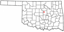
Location within Oklahoma
|
|
| Country | United States |
| State | Oklahoma |
| County | Lincoln |
| Area | |
| • Total | 1.72 sq mi (4.47 km2) |
| • Land | 1.71 sq mi (4.42 km2) |
| • Water | 0.02 sq mi (0.05 km2) |
| Elevation | 1,050 ft (320 m) |
| Population
(2020)
|
|
| • Total | 545 |
| • Density | 316.9/sq mi (121.92/km2) |
| Time zone | UTC−6 (CST) |
| • Summer (DST) | UTC−5 (CDT) |
| ZIP Code |
74832
|
| Area code | 405/572 |
| FIPS code | 40-12100 |
| GNIS ID | 2413172 |
Carney is a small town located in Lincoln County, Oklahoma, in the United States. In 2020, about 545 people lived there.
Contents
History of Carney
Carney has a history like many small towns. One important event happened on May 19, 2013. A very strong tornado, called an EF3 tornado, hit the southeastern part of the town and the areas around it. This event showed how powerful nature can be.
Where is Carney Located?
Carney is located in Oklahoma. The town covers a total area of about 1.8 square miles (or 4.7 square kilometers). This means it's a fairly compact town.
How Many People Live in Carney?
Demographics help us understand the people who live in a place. It's like taking a count of how many people live there and how that number changes over time. The population of Carney has changed over the years:
| Historical population | |||
|---|---|---|---|
| Census | Pop. | %± | |
| 1910 | 260 | — | |
| 1920 | 367 | 41.2% | |
| 1930 | 328 | −10.6% | |
| 1940 | 283 | −13.7% | |
| 1950 | 277 | −2.1% | |
| 1960 | 227 | −18.1% | |
| 1970 | 396 | 74.4% | |
| 1980 | 622 | 57.1% | |
| 1990 | 558 | −10.3% | |
| 2000 | 649 | 16.3% | |
| 2010 | 647 | −0.3% | |
| 2020 | 545 | −15.8% | |
| U.S. Decennial Census | |||
Education in Carney
The students in Carney attend schools that are part of the Carney Public Schools #105 school district. This district serves the community's educational needs.
See also
 In Spanish: Carney (Oklahoma) para niños

