Casarabonela facts for kids
Quick facts for kids
Casarabonela
|
|||
|---|---|---|---|

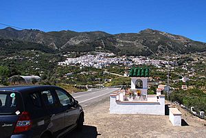
View to Casarabonela
|
|||
|
|||
| Sovereign state | |||
| Autonomous community | |||
| Province | |||
| Area | |||
| • Total | 113.72 km2 (43.91 sq mi) | ||
| Elevation | 514 m (1,686 ft) | ||
| Population
(2018)
|
|||
| • Total | 2,510 | ||
| • Density | 22.07/km2 (57.17/sq mi) | ||
| Time zone | UTC+1 (CET) | ||
| • Summer (DST) | UTC+2 (CEST) | ||
| Website | www.casarabonela.es | ||
Casarabonela is a small town and a municipality in the province of Málaga. This area is part of the Andalusia region in southern Spain. The town is about 48 kilometers (30 miles) from the city of Málaga. It is located near the regions of Antequera and Ronda. About 2,500 people live in Casarabonela. The people who live here are sometimes called Moriscos. This name refers to people of Moorish descent who lived in Spain.
What's in a Name?
The name Casarabonela has a cool history. It comes from an Arabic phrase, "QaSr Bunayra." This means "The Alcazar (Palace) of Bonéra." An alcazar is a type of Spanish castle or palace. Old records, like those from a historian named Ibn al-Qūṭiyya, show this origin. This name tells us about the town's past. It shows its connection to the time when Arabs lived in Spain.
Weather in Casarabonela
Casarabonela has a pleasant climate. It is located at an elevation of about 480 meters (1,575 feet). The weather data below is from 1967 to 1981. It shows the average temperatures throughout the year.
| Climate data for Casarabonela (elevation: 480m, data from 1967-1981) | |||||||||||||
|---|---|---|---|---|---|---|---|---|---|---|---|---|---|
| Month | Jan | Feb | Mar | Apr | May | Jun | Jul | Aug | Sep | Oct | Nov | Dec | Year |
| Mean daily maximum °C (°F) | 15.7 (60.3) |
15.2 (59.4) |
16.8 (62.2) |
17.9 (64.2) |
20.9 (69.6) |
25.0 (77.0) |
29.0 (84.2) |
30.3 (86.5) |
25.0 (77.0) |
22.2 (72.0) |
18.2 (64.8) |
15.9 (60.6) |
21.0 (69.8) |
| Daily mean °C (°F) | 11.7 (53.1) |
11.3 (52.3) |
12.4 (54.3) |
13.2 (55.8) |
15.8 (60.4) |
19.4 (66.9) |
23.2 (73.8) |
24.3 (75.7) |
20.0 (68.0) |
17.5 (63.5) |
14.1 (57.4) |
11.8 (53.2) |
16.2 (61.2) |
| Mean daily minimum °C (°F) | 7.6 (45.7) |
7.5 (45.5) |
7.9 (46.2) |
8.6 (47.5) |
10.7 (51.3) |
13.7 (56.7) |
17.4 (63.3) |
18.3 (64.9) |
15.1 (59.2) |
12.9 (55.2) |
10.0 (50.0) |
7.7 (45.9) |
11.5 (52.7) |
| Source: Sistema de Clasificación Bioclimática Mundial | |||||||||||||
See also
 In Spanish: Casarabonela para niños
 | DeHart Hubbard |
 | Wilma Rudolph |
 | Jesse Owens |
 | Jackie Joyner-Kersee |
 | Major Taylor |


