Castellet de Banyoles facts for kids

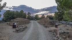
Main entrance to the city
|
|
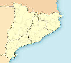
| Location | Tivissa, Province of Tarragona, Catalonia, Spain |
|---|---|
| Coordinates | 41°03'41.5"N 0°40'05.9"E 41°03′41″N 0°40′05″E / 41.06139°N 0.66806°E |
| Type | Settlement |
| Length | 300 m (980 ft) |
| Width | 235 m (771 ft) |
| Area | 4 to 5 ha (12 acres) |
| History | |
| Founded | 3rd century BC |
| Abandoned | c. 195 BC |
| Cultures | Iberians |
| Associated with | Ilercavoni |
| Site notes | |
| Public access | Opened to public |
| Official name | Poblado Ibérico del Castellet de Banyoles |
| Designated | 27 October 1978 |
| Reference no. | RI-55-0000088 |
The Castellet de Banyoles was an ancient Iberian city. It is now an archaeological site in Catalonia, Spain. This city was built around the 4th century BC. It is located near the modern town of Tivissa. The site is close to the Ebro River.
Castellet de Banyoles is famous for its unique entrance. It has five-sided towers on each side of the gate. These towers are special because they are not found in other ancient forts in the Iberian Peninsula (Spain and Portugal). In 1927, a valuable treasure was found here. It included silver and gold decorated bowls. The city was likely destroyed by the Romans around 195 BC. This happened during a Roman attack, possibly led by Cato the Elder.
Contents
What is Castellet de Banyoles?
Castellet de Banyoles means "Banyoles' Little Castle." This name comes from a castle built much later, in the 12th century. This medieval castle was built in one corner of the ancient Iberian city. An old document from 1153 mentions the place as "caput de Bannoles." This means "head" or "bulge" of Banyoles.
Why the name "Banyoles"?
The name "Banyoles" might come from a Latin word for "baths." This could refer to the wet areas around the site. It might also come from a person's name.
Where is Castellet de Banyoles Located?
The ancient city is about 7 kilometers (4.3 miles) from the modern town of Tivissa. It sits on a flat piece of land that faces the Ebro River. The site is about 172 meters (564 feet) above sea level.
The City's Shape and Defenses
The land where the city was built looks like a triangle. The shortest side of the triangle faces the river. The city's entrance is at the closest point of this triangle. Steep cliffs surround the site. This made it very hard to get into the city from anywhere except the narrow entrance. Outside the city walls, there were about 7,000 hectares (17,300 acres) of farmland. This land was used to grow food for the city's people.
See also
 In Spanish: Castellet de Banyoles para niños
 | John T. Biggers |
 | Thomas Blackshear |
 | Mark Bradford |
 | Beverly Buchanan |


