
Castle Frank Brook facts for kids
Quick facts for kids Castle Frank Brook |
|
|---|---|
.jpg)
Rosedale Ravine, 1890
|
|

Location of the mouth of Castle Frank Brook in Toronto
|
|
| Country | Canada |
| Province | Ontario |
| Region | Greater Toronto Area |
| Municipality | Toronto |
| Physical characteristics | |
| Main source | Fairbank Reach 177 m (581 ft) 43°42′58″N 79°27′16″W / 43.71611°N 79.45444°W |
| River mouth | Don River 76 m (249 ft) 43°40′11″N 79°21′31″W / 43.66972°N 79.35861°W |
| Length | 12 km (7.5 mi) |
| Basin features | |
| Tributaries |
|
The Castle Frank Brook is a creek in Toronto, Ontario. It's mostly a buried stream, meaning it flows underground. It's also an urban creek, which means it runs through a city. This creek is a branch of the Don River. It starts near Lawrence Avenue and Dufferin Street in central and north-western Toronto.
Contents
Discovering Castle Frank Brook's Path
Over time, buildings and roads have covered much of the original path of Castle Frank Brook. This happened as the areas of York and North York grew. However, you can still see parts of its old valley in some older neighbourhoods.
Visible Sections of the Brook
Even though most of the brook is hidden, some parts of its valley are still clear.
- Cedarvale Park ravine: Here, you can see a section of the valley.
- Nordheimer Ravine: This area is near St. Clair Avenue and Spadina Road.
- Rosedale Ravine: This is close to where the brook joins the Don River.
In Cedarvale Park and the Nordheimer Ravine, you can still see small amounts of water flowing. This water comes from rain and seepage from the hillsides. These small streams flow into storm sewers, which then carry the rest of the brook underground.
How the Brook Shaped the Land
The path of the brook also influenced how some roads were built. For example, the southern part of Vaughan Road follows the brook's course. This helped avoid the steep slopes of the Cedarvale ravine. You can also see the brook's impact at Ramsden Park. This park is north of Avenue Road and Davenport Road. It marks the edge of the busy Yorkville area.
The Toronto Transit Commission's Spadina subway line also follows the brook's path. It runs from Eglinton West station to St. Clair West station. After that, it turns south at Spadina Road.
The Story Behind the Name
The name "Castle Frank Brook" comes from a summer home. This home belonged to John Graves Simcoe. He was the first colonial governor of Ontario. Simcoe named his home after his son, Francis Gwillim.
Where Was Castle Frank?
The original Castle Frank home was built either on the west side of the Don River. Or it was on the east side of Cabbagetown, close to the river. The house had a classic Georgian style. Simcoe left the home when he went back to England in 1794. The house later burned down in 1829.
Castle Frank's Legacy Today
The Castle Frank subway station is named after this historic home. Another house with the same name was built north of the original site. This second home was built by Sir Edward Kemp. It was torn down in 1962 to make way for the Rosedale Heights School of the Arts. If you look at old aerial photos, you can still see where the first summer home was. It looks like a partly cleared area with a ring shape.
Images for kids
-
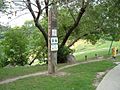
Cedarvale Park sign
-
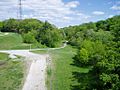
The Nordheimer Ravine, named after Samuel Nordheimer, a piano importer who lived nearby
-
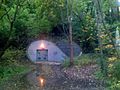
The Russell Hill Emergency exit in Winston Churchill Park
-
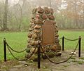
Historical marker near Castle Frank station, placed in 1954
-
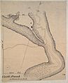
Map showing Castle Frank in 1794
-
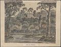
Sketch of Castle Frank by Elizabeth Simcoe, 1796


