
Castle Mountains (Montana) facts for kids
Quick facts for kids Castle Mountains |
|
|---|---|

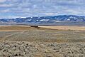
Western face of Castle Mountains near Ringling, Montana
|
|
| Highest point | |
| Peak | Elk Peak (Meagher County, Montana) |
| Elevation | 8,589 ft (2,618 m) |
| Geography | |
| Country | United States |
| State | Montana |
The Castle Mountains are a cool mountain range in Montana, United States. Their tallest point is called Elk Peak, which is 8,589 feet (2,618 m) high! They are located east of White Sulphur Springs in Meagher County, Montana.
A big part of these mountains, about 30,000 acres, didn't have any roads back in 1995. This means they were wild and untouched! The western side of the Castles gets more rain and is moist. But the eastern side has dry, rocky hills made of limestone.
Contents
Why Are They Called Castle Mountains?
The mountains get their name from special rock formations. These look like "castle turrets" and are about 50 feet tall! You can find these cool, tower-like rocks on the western slopes. They are made of igneous rock, which forms from cooled lava.
Exploring the Landscape
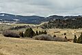
The Castle Mountains have a unique look. In the middle, you'll find a group of peaks that are over 8,000 feet high. Around these peaks are wide, grassy areas called "parks." These parks are surrounded by tall trees like lodgepole pine and limber pine.
A Look Back at Mining
Long ago, these mountains were a busy place for mining. People came here to dig for valuable minerals. Today, you can still see old, crumbling cabins where miners used to live. You might also find old digging sites throughout the area. These remains are like clues to the mountains' past.
Fun in the Castle Mountains
Not many people visit the Castle Mountains for fun, except for hunters in the fall. It's a quiet place for outdoor activities.
Reaching the Peak
If you love a challenge, you might try to reach the top of Castle Mountain itself. There isn't a clear path or trail leading to the very peak. But if you make it, there's a special login book waiting for you. It's a way for the few people who reach the top to leave their mark!
Images for kids
-
Southern face of Castle Mountains from Ringling, Montana
-
Southeastern corner of Castle Mountain on Castle Town road


