Causapscal River facts for kids
Quick facts for kids Causapscal River |
|
|---|---|

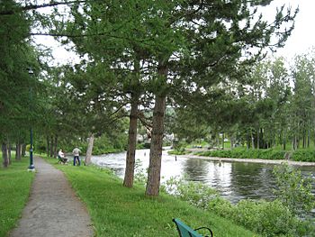
Salmon fishers at Les Fourches stream pool at the junction of the Matapedia and Causapscal Rivers
|
|
| Physical characteristics | |
| River mouth | Matapedia River 48°21′12″N 67°13′22″W / 48.35333°N 67.22278°W |
| Length | 60.9 km (37.8 mi) |
The Causapscal River is a beautiful waterway about 61 kilometers (38 miles) long in Quebec, Canada. It flows through the Matapedia Valley in the Bas-Saint-Laurent and Gaspésie-Îles-de-la-Madeleine regions. This river is a tributary, meaning it flows into a larger river, which in this case is the Matapedia River. The special spot where these two rivers meet is called Les Fourches, which means 'The Forks' in French. This area is also known as a great place for salmon fishing.
The Causapscal River flows through several areas, including the city of Causapscal and other unorganized territories like Lac-Casault. It eventually empties into the east bank of the Matapedia River right in the city of Causapscal.
Contents
Where Does the River Start?
The Causapscal River begins its journey in the Dunière Wildlife Sanctuary. This area is part of the Chic-Choc Mountains, which are themselves a part of the larger Notre Dame Mountains. Imagine a tiny stream high up in these mountains; that's where the Causapscal River gets its start!
The source of the river is located in La Verendrye (township). From there, the river flows generally south and southwest, making its way through different landscapes.
The River's Journey
The Causapscal River's path is about 73 kilometers (45 miles) long. It can be thought of in two main parts:
Upper Course of the River
The upper part of the river stretches for about 43.6 kilometers (27 miles). Here, the river winds its way through wilder areas. It passes through the Zec Casault, which is a controlled harvesting zone, and collects water from smaller streams like Lévesque stream and Bacon Creek. It also connects with Lake North and Lake Lavoie.
Further along, the river meets the South Causapscal River. It then flows through different townships, picking up water from other streams like Gun Creek and Pelletier stream. It also receives water from Lake Bergeron. A notable point in this section is where it meets the Casault River, which flows out of Lake Casault and Lake Causapscal. These two lakes are very close, separated by just a small strip of land.
Lower Course of the River
The lower part of the river covers about 29.8 kilometers (18.5 miles). In this section, the river continues its journey south and southwest. It flows through the unorganized territory of Lac-Casault and then into Saint-Alexandre-des-Lacs.
Finally, the river enters the city of Causapscal. It flows through a deep valley, passing under the bridge of Saint-Jacques Street in the heart of the city. Just a short distance further, it reaches its end, joining the Matapedia River. This meeting point is about 49.4 kilometers (30.7 miles) northwest of where the Matapedia River itself joins the Restigouche River.
Fishing and Wildlife
The Causapscal River is very famous for its amazing Atlantic salmon fishing! People come from all over to fish here, either by wading in the water or using canoes. About 31 kilometers (19 miles) of the river are open for fishing. This area is divided into 25 special spots called "salmon pools."
The salmon in the Causapscal River can be quite large, sometimes weighing up to 55 pounds (about 25 kg)! Each year, between 450 and 600 salmon swim up the river. To keep the fishing fair and sustainable, the river is split into two main fishing areas, each with a limit on how many fishing poles can be used each day. Access to these spots is often decided by a draw.
Here are some of the well-known salmon pools along the river:
| Salmon pools | Municipality |
|---|---|
| Sector 1 | |
| 2nd Mille | Causapscal |
| 3rd Mille | Causapscal |
| 4th Mille | Causapscal |
| Bas Jumeau (Lower Twin) | Causapscal |
| Jumeau | Causapscal |
| Des Aulnes | Causapscal |
| Du Vieux Camp | Causapscal |
| De la Grande Grève | Causapscal |
| De l'Île du 7e Mille | Causapscal |
| Du Pont du Huit-Mille | Causapscal |
| De l'Île du 7e Mille | Causapscal |
| Sector 2 | |
| De la Dernière Chance (From Last Chance) | Causapscal |
| Du Grand Remous | Causapscal |
| Neese | Causapscal |
| Potvin | Lac-Casault |
| Florence | Lac-Casault |
| Castonguay | Lac-Casault |
| Du 11e Mille | Lac-Casault |
| Du Bateau | Lac-Casault |
| Des Chutes | Lac-Casault |
| White Horse | Lac-Casault |
| Du Pont des Falls | Lac-Casault |
| Du Camp Draveurs | Lac-Casault |
| Bas Martel | Lac-Casault |
| Martel | Lac-Casault |
What's in a Name?
The name "Causapscal" is quite important in the Matapedia Valley. You'll find this name used for many other places in the area, not just the river!
The name "Causapscal River" was officially recognized on December 5, 1968, by the Commission de toponymie du Québec, which is like Quebec's official board for place names.
 | Stephanie Wilson |
 | Charles Bolden |
 | Ronald McNair |
 | Frederick D. Gregory |

