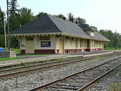
Matapedia Valley facts for kids
Quick facts for kids Matapedia Valley |
|
|---|---|
| Vallée de la Matapédia | |
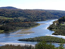
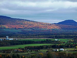
Landscape in the Matapedia Valley at the junction of the Matapedia and Restigouche rivers
|
|
| Length | 375 km (233 mi) southwest |
| Geology | |
| Type | river valley |
| Geography | |
| Population centers | Amqui |
| Traversed by | |
The Matapedia Valley (which is vallée de la Matapédia in French) is a long valley in eastern Quebec. It was shaped by the Chic-Choc Mountains. The valley gets its name from the Matapedia River and Lake Matapedia, which are both found there.
This valley is located in the southwest part of the Gaspé Peninsula. It stretches for about 375 kilometers (233 miles). The area is mostly covered by forests and farms. More than 20,000 people live here, spread across about thirty towns and villages. Most people live near the main road, Route 132. The largest town is Amqui, which is home to 6,261 people.
The Mi'kmaq people were the first to live in the valley around 500 BCE. French-Canadian settlers began to arrive in 1833. This was when Pierre Brochu moved to Lake Matapedia. More settlers came in the late 1800s as farming and logging grew.
Contents
What's in a Name? Understanding Matapedia
The name Matapedia likely comes from the Mi'kmaq language. The word matapegiag means "river junction." This refers to the Matapedia River joining the Restigouche River.
An old linguist named Silas Tertius Rand said the Mi'kmaq called the area Magabegeak, meaning "roughly flowing." Over time, the name has been spelled in many different ways. Some of these include Matapediach, Madapeguia, Matapeguia, Matapediac, Matakpediack, Madapeguia, Metapedia, and Matapediac.
Exploring the Matapedia Valley's Geography
Where is the Matapedia Valley Located?
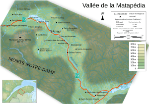
The Matapedia Valley starts in the west at the village of Sainte-Angèle-de-Mérici, Quebec. It runs for 375 kilometers (233 miles) from north to south. It ends at the Restigouche River in the east, which is near the border with New Brunswick. The village of Matapédia, Quebec is at the eastern end of the valley.
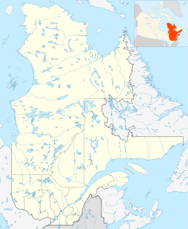
The valley is south of the Saint Lawrence River. It is part of the Bas-Saint-Laurent and Gaspésie–Îles-de-la-Madeleine regions. This makes it special because it's the only part of the Gaspé Peninsula that doesn't touch the sea.
What Does the Land Look Like?
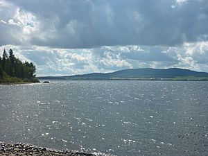
The Matapedia Valley is carved into the Chic-Choc mountain range. These mountains are at the northern end of the Appalachians. The valley has two main lakes. One is Lake Matapedia, which stretches from Sayabec to Amqui. The other is Lac-au-Saumon, located in the town of the same name.
The valley goes from the St. Lawrence River all the way to Chaleur Bay. The northwest part of the valley is quite flat. It has small mountains that are less than 400 meters (1,312 feet) high. In the middle of the valley, near St. Cleophas and St. Irène, the peaks are higher, reaching about 800 meters (2,625 feet). One of these is the Val-d'Irène ski resort, which is 685 meters (2,247 feet) high.
The southeastern part of the valley is more rugged and steep. Here, the mountain tops reach about 600 meters (1,969 feet). Lake Matapedia itself is at an altitude of 158 meters (518 feet).
The Matapedia Valley has 20,000 hectares (77 square miles) of farmland. It also has 500,000 hectares (1,931 square miles) of forest. This forest is split evenly between public and private land. The main farming towns are Amqui, Causapscal, Saint-Damase, Val-Brillant, and Saint-Léon-le-Grand.
The valley floor is made of Appalachian rock. It mostly has Gaspé feldspar sandstone and Gaspé limestone. There's also a mix of sandstone, mudstone, and limestone from the Chaleur Group. These rocks date back to the Devonian and Silurian periods.
Waterways of the Matapedia Valley
The Matapedia Valley's water flows through the Matapedia River. This river's watershed (the area that drains into it) is 3,824 square kilometers (1,476 square miles). The river is famous for its Atlantic salmon fishing.
The valley also has over 200 lakes. The biggest one is Lake Matapedia, which covers 38 square kilometers (15 square miles). The second largest lake is Lac-au-Saumon. The Matapedia River flows into and out of Lac-au-Saumon.
Who Lives in the Matapedia Valley?
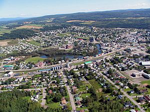
The Matapedia Valley includes three regional county municipalities: La Mitis, La Matapédia, and Avignon. These cover about thirty towns and villages. Important towns for the economy are Amqui, Causapscal, and Sayabec.
Today, more than 20,000 people live in the valley. The population is much denser along Lake Matapedia and the Matapedia River. In these areas, there are 12 people per square kilometer. In the higher, more remote parts of the valley, there are only 5 people per square mile. The undeveloped areas of the valley are almost empty.
| Year | Population |
|---|---|
| 1895 | 8,000 |
| 1922 | 30,000 |
| 2006 | 20,000 |
| Municipality | Population | Year of incorporation |
|---|---|---|
| La Mitis RCM | ||
| Sainte-Angèle-de-Mérici | 1,081 | 1989 |
| Padoue | 283 | 1911 |
| Sainte-Jeanne-d'Arc | 322 | 1922 |
| La Rédemption | 219 | 1968 |
| La Matanie RCM | ||
| Sainte-Paule | 322 | 1922 |
| La Matapédia RCM | ||
| Saint-Damase | 429 | 1885 |
| Saint-Noël | 515 | 1906 |
| Saint-Moïse | 661 | 1878 |
| Sayabec | 1,953 | 1982 |
| Saint-Cléophas | 450 | 1921 |
| Val-Brillant | 1,003 | 1986 |
| Sainte-Irène | 308 | 1953 |
| Amqui | 6,395 | 1991 |
| Saint-Alexandre-des-Lacs | 275 | 1965 |
| Saint-Tharcisius | 510 | 1937 |
| Saint-Vianney | 520 | 1926 |
| Lac-au-Saumon | 1,517 | 1997 |
| Saint-Léon-le-Grand | 1,073 | 1903 |
| Saint-Zénon-du-Lac-Humqui | 427 | 1920 |
| Albertville | 350 | 1950 |
| Causapscal | 2,556 | 1997 |
| Sainte-Florence | 458 | 1911 |
| Sainte-Marguerite-Marie | 242 | 1957 |
| Avignon RCM | ||
| Saint-André-de-Restigouche | 220 | 1855 |
| Ristigouche-Partie-Sud-Est | 176 | 1906 |
| Saint-François-d'Assise | 795 | 1926 |
| Saint-Alexis-de-Matapédia | 660 | 1855 |
| L'Ascension-de-Patapédia | 221 | 1968 |
| Matapédia | 758 | 1905 |
Getting Around: Transportation in the Valley
The main road in the Matapedia Valley is Highway 132. It runs from northwest to southeast. Most of the people in the valley live along this highway. There are also two other provincial highways that cross the valley. Highway 297 goes from Saint-Moïse to Baie-des-Sables. Highway 195 runs from Amqui to Matane.
A railroad also crosses the valley, following the same path as Highway 132. This railway connects to New Brunswick and the Gaspé peninsula. Two trains serve the valley: the Ocean and the Montreal – Gaspé train. Both are run by Via Rail and combine at Matapédia.
A Look Back: History of the Matapedia Valley
Early Inhabitants: Before European Settlers
The Mi'kmaq and Maliseet peoples lived in the Matapedia Valley before Europeans arrived in North America. They mostly lived around Chaleur Bay. However, they would travel along the Matapedia River to fish at the mouth of the Mitis River on the St. Lawrence River. Around 500 BC, the Mi'kmaq started to settle deeper into the valley.
In 1694, the governor of New France, Louis de Buade de Frontenac, gave the land around Lake Matapeguia to Charles-Nicolas-Joseph D'Amours de Louviers. This land was called a seigneurie. However, D'Amours never visited the valley or sent anyone to develop the land. He died in 1728 without passing on the land. Because of this, when Kempt Road was built in 1830, everyone thought the land belonged to the government.
Later, Marie-Françoise Damours de Louvières inherited part of the seigneurie. She married Jean-Baptiste de Remond Moyse, who left his share to their son Jean-Baptiste Raymond. Due to money problems, he sold the entire seigneurie to Patrick Langan in 1796. The Mi'kmaq continued to live in the region until 1818. Then, Scottish families built homes in Métis, and loyalists settled on the Restigouche River. These two places mark the edges of the Matapedia Valley.
First European Explorations
For a long time, the inner part of the valley was not explored by settlers. In 1815, the governor of Lower Canada, Sir James Kempt, sent Joseph Bouchette to explore the Matapedia Valley. His job was to plan a road to connect Métis on the St. Lawrence River to Pointe-à-la-Croix near Chaleur Bay. Bouchette wrote that the Matapedia Valley was a good place for farming.
Around this time, the War of 1812 showed that Canada needed better connections between its different parts. People in Gaspesia had been asking for ways to communicate with cities. In winter, ice cut them off from the rest of the world.
The postal service used a difficult path from Kamouraska to Lake Témiscouata. This path was not good enough for the growing needs of the region. So, the idea for a new road through Lake Matapedia was born. This road, called Kempt Road, would connect the St. Lawrence coast and Chaleur Bay. It was also important for military reasons.
In 1824, James Crawford took over from Joseph Bouchette. He was sent to find the best path for the new road. In his report, he said that the route through Lake Matapedia from Métis was longer but easier. However, he noted that the land east of Lake Matapedia would be harder to build on, even along the river, because of steep banks. Crawford also mentioned that there was no walking path in the Matapedia Valley. He said building one would help the local people. Six years later, Governor Aylmer started the project. By 1845, only the western part, from Métis to Lake Matapedia, was finished.
The First European Settlers Arrive
The first European to live in the Matapedia Valley was Pierre Brochu (1795-1871). In 1833, he settled in what is now Sayabec. This was at the point where Lake Matapedia meets the Saint-Pierre river. He worked as a guardian along Kempt Road, helping couriers and travelers. Lake Matapedia was even called Brochu's Lake until Pierre Brochu died in 1871.
Other guardians included Malcolm Fraser, who settled in Saint-Moïse. Georges Brochu, Pierre's son, settled at the end of Lake Matapedia near Amqui. Georges Lebel settled in Lac-au-Saumon. Jonathan Noble lived where the Causapscal church is today. In 1849, Thomas Evans settled on the Assemetquaghan stream in Routhierville. Noble's son also settled near his father in The Forks, now known as the Forks Park in Causapscal. Ferdinand Duval made his home in Lac-au-Saumon. During this time, Acadians from Prince Edward Island and the Magdalen Islands also started to arrive. They began clearing land and settling in the western part of the Matapedia Valley.
By the 1880s, the valley had about 1,700 people. By the early 1900s, this number had grown to 8,000.
Roads That Shaped the Valley: Kempt and Matapedia Roads
Kempt Road was in very bad condition for a long time. But the American Civil War made the government worry. They finally decided to spend money to build a proper road. The original path was changed to start at Sainte-Flavie instead of Métis. Starting in 1860, Matapedia Road began to replace Kempt Road. Finally, in 1867, Matapedia Road was finished.
The Intercolonial Railway's Impact
In October 1864, a meeting in Quebec decided to connect the Intercolonial Railway to the Grand Trunk Railway at Rivière-du-Loup. In 1871, construction began on a railroad crossing the valley. This project was completed in 1876.
This railway, along with the Matapedia and Kempt roads, helped the valley grow a lot. Between 1900 and 1940, the population of the valley increased to over thirty thousand people.
Culture in the Matapedia Valley
Throughout its history, the Matapedia Valley has shared a lot of its culture with the Acadians. You can see the Acadian flag in many towns in the area. These include Amqui, Causapscal, and Lac-au-Saumon.
Fun Things to Do: Tourism in the Valley
The Matapedia Valley is a popular place for tourists in Gaspésie. The valley is well-known for outdoor activities. These include skiing, hunting, and fishing. Salmon fishing is very popular on the Matapedia River. Val-d'Irène offers 26 trails for snowboarders and downhill skiers. It also has many trails for snowshoeing. For people who like to hike, the International Appalachian Trail goes through the valley. Also, the Seignory of Lac-Matapédia regional park has many trails through the Chic-Chocs mountains.
See also
 In Spanish: Valle de la Matapédia para niños
 | Bayard Rustin |
 | Jeannette Carter |
 | Jeremiah A. Brown |


