
Magdalen Islands facts for kids
|
Native name:
Îles de la Madeleine
|
|
|---|---|

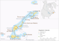
The Magdalen Islands
|
|
| Geography | |
| Location | Gulf of Saint Lawrence |
| Coordinates | 47°26′54″N 61°45′08″W / 47.44833°N 61.75222°W |
| Area | 205.53 km2 (79.36 sq mi) |
| Administration | |
|
Canada
|
|
| Province | Quebec |
| Demographics | |
| Population | 12,781 (2011) |
| Pop. density | 62.2 /km2 (161.1 /sq mi) |
| Additional information | |
| Time zone | |
| • Summer (DST) | |
| Area code(s) | 418 and 581 |
The Magdalen Islands (in French: Îles de la Madeleine) are a small group of islands in the Gulf of Saint Lawrence. They cover an area of about 205.53 square kilometers (79.36 sq mi). Even though they are part of the province of Quebec, these islands are actually closer to Canada's Maritime provinces.
The islands are managed as part of the Gaspésie–Îles-de-la-Madeleine region in Quebec. They form a special area called the Urban Agglomeration of Les Îles-de-la-Madeleine. This area has two main towns: Les Îles-de-la-Madeleine and Grosse-Île. In 2011, about 12,781 people lived on the islands.
Contents
Exploring the Geography

The Magdalen Islands are made up of eight main islands. These include Amherst, Grande Entrée, Grindstone, Grosse-Île, House Harbour, Pointe-Aux-Loups, Entry Island, and Brion. All of these islands are inhabited except for Brion Island.
There are also a few smaller islands nearby. These include Bird Rock (Rocher aux Oiseaux), Seal Island (Île aux Loups-marins), Île Paquet, and Rocher du Corps Mort.
Deep below the islands is an ancient salt dome. This salt pushes upwards, causing the red sandstone above it to rise. This area also has a salt mine that digs up rock salt.
Coastal Changes
The coastlines of the Magdalen Islands are changing a lot due to erosion. This means the land is slowly being worn away by the sea. Since 2005, the rate of erosion has doubled. On average, the islands lose about half a meter (20 inches) of land each year.
Big storms, like a strong windstorm in 2018 and Hurricane Dorian in 2019, have made the problem worse. Also, the ocean around the islands is getting warmer. This means there is less ice cover in winter, which usually protects the shores from strong waves. Without this ice, the islands are more exposed to winter storms.
Scientists have found that sea levels around the islands are rising faster than the global average. This rise in sea levels, combined with less ice, causes the islands to crumble into the sea. Some areas have lost as much as 14 feet of shoreline in a single year! This erosion threatens roads, buildings like the hospital and city hall, and even the fresh drinking water supply. Because of this, some homes have already had to be moved.
A Look at History


In 1534, the explorer Jacques Cartier was the first European known to visit the islands. However, the Mi'kmaq people had been coming to the islands for hundreds of years before that. They visited seasonally, likely to hunt the many walruses found there.
The islands were named in 1663 by François Doublet. He named them after his wife, Madeleine Fontaine.
By 1765, about 22 French-speaking Acadians and their families lived on the islands. They worked for a British trader, hunting walruses. Many people on the Magdalen Islands today still feel a strong connection to their Acadian heritage. They often fly the Acadian flag.
From 1763 to 1774, the islands were part of the British Colony of Newfoundland. Then, they became part of Quebec through the Quebec Act.

Some islanders are descendants of people who survived shipwrecks. More than 400 ships have been wrecked near the islands over time. Some old houses on the islands were even built using wood from these shipwrecks!
The islands also have some of Quebec's oldest English-speaking communities. While many English speakers have either learned French or moved away, some English-speaking settlements still exist in places like Old Harry, Grosse-Ile, and Entry Island.
To make the seas safer, lighthouses were built on the islands. These lights guide ships and have helped reduce the number of shipwrecks. Still, you can find many old ship parts on the beaches and under the water.
Until the 1900s, the islands were completely cut off during winter. Thick ice made it impossible for boats to reach the mainland. There was no way to communicate with the mainland either. An underwater telegraph cable was installed, but in 1910, it broke. The islands were isolated again. Residents sent an urgent message for help by putting letters inside a molasses barrel and letting it float away. This barrel reached Cape Breton Island, and the government sent an icebreaker to help.
After this, new wireless telegraph stations were built to ensure the islands always had communication in winter. The famous molasses barrel became a symbol of survival, and you can find replicas in tourist shops today.
Long ago, large groups of walrus lived near the islands. However, too much hunting caused them to disappear by the late 1700s. Today, the islands' beaches are home to endangered birds like the piping plover and the roseate tern.
Life on the Islands
Population and Language
In 2011, the Magdalen Islands had a population of 12,781 people. Most residents speak French as their first language. About 94% of the population speaks French, while about 5.5% speak English. A very small number of people speak both French and English, or other languages.
Climate
The Magdalen Islands have a unique climate because they are surrounded by a lot of water. This water keeps the weather milder in all seasons. Winters are not as cold as on the mainland, spring is cool, summer has some warm days, and fall stays warm. The islands have the fewest days with frost in Quebec.
The highest temperature ever recorded was 31.1°C (88°F) on July 31, 1949. The lowest temperature ever recorded was -27.2°C (-17°F) on February 14, 1891.
The islands have warmed by 2.3°C (4.1°F) since the late 1800s. This is twice the global average warming. This warming affects the sea ice, which used to protect the islands from winter storms. The sea ice is shrinking, leaving the islands more exposed to erosion and rising sea levels.
Fun for Visitors

Tourism is a very important industry for the islands. They are famous for their many kilometers of beautiful white sand beaches and colorful sandstone cliffs. The islands are a great place for bicycle camping, sea kayaking, windsurfing, and kitesurfing.
In winter, starting in mid-February, people visit to see newborn harp seal pups. These baby seals are born on the floating ice in the Gulf of Saint Lawrence around the islands. However, because the ice cover has been shrinking, these seal-watching tours have sometimes been canceled.
Island Industries
The islands are home to the Canadian Salt Company Seleine Mines. This mine produces road salt that is used in Quebec, Atlantic Canada, and the eastern United States. The salt mine opened in 1982 and is located in Grosse-Île. It digs salt from an underground mine about 30 meters (98 feet) below the Grande-Entrée Lagoon. The mine produces about 1 million tons of salt each year and employs 200 people.
Fishing has always been a traditional job on the islands. Recently, lobster fishing has become a very profitable business. Lobster fishers used to catch about 15,000 pounds during their nine-week season. Now, it's common for them to catch twice that amount or even more! This increase might be because the warming ocean waters are helping the lobster population grow.
Getting Around

The CTMA (Coopérative de Transport Maritime et Aérien) operates a ferry service. This ferry connects Souris, Prince Edward Island, to Cap-aux-Meules on the Magdalen Islands. CTMA also runs a seasonal cruise ferry service between the islands and Montreal.
The Magdalen Islands Airport is located at Havre-aux-Maisons. It offers regular flights to the mainland of Quebec. During certain seasons, you can also fly to Saint-Pierre and Miquelon, which is a French overseas territory.
Images for kids
-
The Magdalen Islands
-
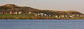
A view of the Magdalen Islands' coastline.
-
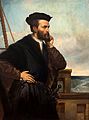
Jacques Cartier, an early European explorer.
-

The Acadian flag.
-
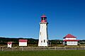
The Anse-à-la-Cabane lighthouse.
-
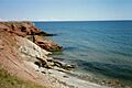
Cliffs along the shore of Grosse Île.
-
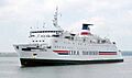
The Madeleine ferry.
See also
 In Spanish: Islas de la Magdalena para niños
