
Lake Matapedia facts for kids
Quick facts for kids Lake Matapedia |
|
|---|---|

Northwest corner of the lake, at Sayabec
|
|

Lake Matapedia
Location in Quebec
|
|
| Location | La Matapédia Regional County Municipality, Quebec |
| Coordinates | 48°33′N 67°33′W / 48.550°N 67.550°W |
| Primary outflows | Matapédia River |
| Basin countries | Canada |
| Max. length | 19 km (12 mi) |
| Max. width | 3 km (1.9 mi) |
| Surface area | 38 km2 (15 sq mi) |
Lake Matapedia is a beautiful body of water in Quebec, Canada. It is located in the Matapedia Valley. This lake is the source of the Matapedia River. You can find it in different areas like Lac-Matapédia, Sayabec, and Val-Brillant. The town of Amqui is right at the southeast end of the lake.

Contents
Where is Lake Matapedia?
Lake Matapedia is quite large! It covers about 38 square kilometers (14.6 square miles). It stretches for 19 kilometers (about 12 miles) long. The lake is up to 3 kilometers (about 1.8 miles) wide. It sits between the towns of Sayabec and Amqui.
This lake is in the middle of the Matapedia Valley. It was formed by the Appalachian Mountains, specifically the Notre Dame Mountains. Lake Matapedia is about 30 kilometers (18.6 miles) south of Matane.
Several streams flow into Lake Matapedia. One important one is the Sayabec River. The town of Sayabec is located at the mouth of this river. The lake's water then flows out into the Chaleur Bay through the Matapedia River and the Restigouche River. People often call Lake Matapedia the "Jewel of the Valley." The towns right next to the lake are Sayabec, Val-Brillant, and Amqui.
The Story Behind the Name
The name "Matapedia" has been spelled in different ways over time. In 1807, it appeared as "L. Matapediuch" on a map. Later, in 1815, a geographer named Joseph Bouchette called it "Lac Malapediach." He also wrote "Metapediach" in his book's index.
In 1863, another geographer, Stanislas Drapeau, used "Matapediac" on a map. However, in the text of his book, he used the spelling "Matapedia." This is the same spelling we use today. The current spelling, "Matapedia," was used on a map of Quebec in 1870.
The Mi'kmaq people, who are Indigenous to the area, have their own meaning for the name. Father Pacifique said that "Matapedia" comes from "matapegiag." This means "the river splits into several branches" or "makes a fork." Another person, Joseph-Étienne Guinard, thought it meant "junction of rivers." This comes from "mata" (junction) and "pegiag" (river).
The name "Lac Matapédia" was officially registered on December 5, 1968. This was done by the Commission de toponymie du Québec.
Fun Things to Do at Lake Matapedia
Lake Matapedia is a great place for tourism and outdoor activities. You can enjoy many water sports here. These include fishing, sailing, windsurfing, and swimming. The lake is not too crowded, so it's easy to enjoy these activities.
There is a marina in Val-Brillant where you can dock boats. In Sayabec, you can visit the Pierre-Brochu observation and boat launch park. The fine point of Amqui has a large beach. Here, you can go camping and even try wakeboarding.
You can also find a camping site and a beach at Charlie's Bay in Sayabec. There's another campground at the Val-Brillant marina. Lake Matapedia is part of the Gaspésie tourist region. The International Appalachian Trail runs along the north shore of the lake. This trail connects Causapscal to the Réserve faunique de Matane.
Images for kids
-
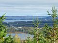
Lake Matapédia view from Val-Brillant
-
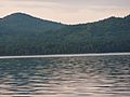
North shore of Lake Matapédia in front of Val-Brillant
-
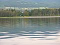
South shore of Lake Matapédia at Val-Brillant
-
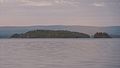
Islands of Lake Matapédia at the level of Val-Brillant


