
Sayabec facts for kids
Quick facts for kids
Sayabec
|
||
|---|---|---|
|
Municipality
|
||
 |
||
|
||

Location within La Matapédia RCM.
|
||

Sayabec
Location in Eastern Quebec
|
||
| Country | ||
| Province | ||
| Region | Bas-Saint-Laurent | |
| RCM | La Matapédia | |
| Settled | mid 19th century | |
| Constituted | December 24, 1982 | |
| Area | ||
| • Total | 138.50 km2 (53.48 sq mi) | |
| • Land | 130.48 km2 (50.38 sq mi) | |
| Population
(2011)
|
||
| • Total | 1,864 | |
| • Density | 14.3/km2 (37/sq mi) | |
| • Pop 2006-2011 | ||
| • Dwellings | 879 | |
| Time zone | UTC−5 (EST) | |
| • Summer (DST) | UTC−4 (EDT) | |
| Postal code(s) |
G0J 3K0
|
|
| Area code(s) | 418 and 581 | |
| Highways | ||
.svg)
Sayabec is a small town, also called a municipality, in Quebec, Canada. It's found in the beautiful Matapédia Valley, nestled between the Chic-Choc Mountains and near Lake Matapédia. About 2,000 people live here, making it the third largest town in its area, the La Matapédia Regional County Municipality. Sayabec is known for its farming and logging. It's also an important place for the economy because of a big wood factory called Panval.
Contents
History of Sayabec
Sayabec has a rich history that dates back many years.
First People and Early Settlers
Long ago, the land where Sayabec now stands was home to the Mi'kmaq people. They are a First Nation group who lived across much of the Gaspe Peninsula. The first French Canadian person to settle here was Pierre Brochu, who arrived in 1833.
Growing into a Town
Towards the end of the 1800s, more people started to move to the region. They came to work in the sawmills, which were important for the area's economy.
The town officially began to take shape in 1887. It was first called Sainte-Marie-de-Sayabec and was set up as a school municipality. A Catholic church parish was also established in 1894.
In 1917, a new village called Saindon was created. This village later changed its name to Sayabec in 1951. Finally, in 1982, the parish of Sainte-Marie-de-Sayabec and the village of Sayabec joined together to form the municipality we know today.
Getting Around Sayabec
Sayabec is connected to other places by important roads and railways.
Roads and Highways
The main road that helps people travel to and from Sayabec is Quebec Route 132. This highway goes all the way around the Gaspe Peninsula and connects back towards the Mont-Joli area, which is northwest of Sayabec.
Railways
Sayabec is also located along the Canadian National Railway. This railway was originally known as the Intercolonial Railway and has been an important way to transport goods and people for a long time.
Images for kids
-
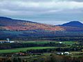
View of the Chic-Choc Mountains from Sayabec
-
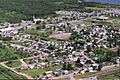
Aerial view of Sayabec
-
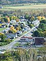
Rue de l'Église (Church Street)
-
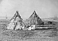
Mi'kmaq camp, circa 1857
-
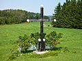
Roadside cross erected in 1875 by Marceline Brochu, wife of Pierre Brochu
-
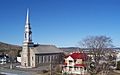
Sayabec's church
-
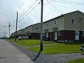
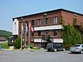
HLMs in Sayabec
-
Pavillon Saindon
-
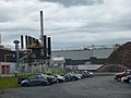
Panval, the big wood factory
-
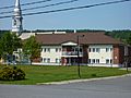
Sayabec's city hall


See also
 In Spanish: Sayabec para niños
