
Celeron Island, Michigan facts for kids

USGS aerial imagery of Celeron Island
|
|

Celeron Island
Location in Wayne County, Michigan

Celeron Island
Location in Michigan

Celeron Island
Location in the United States
|
|
| Geography | |
|---|---|
| Location | Michigan |
| Coordinates | 42°04′47″N 83°10′24″W / 42.07972°N 83.17333°W |
| Highest elevation | 571 ft (174 m) |
| Administration | |
|
United States
|
|
| State | |
| County | Wayne |
Celeron Island is a small island located in the Detroit River. It is found in Wayne County, in the southeastern part of Michigan. This island is the southernmost one within Grosse Ile Township. Its exact location is 42°04′47″N 83°10′24″W / 42.07972°N 83.17333°W. In 1980, the United States Geological Survey measured its elevation as about 571 feet (174 meters) above sea level.
Contents
About Celeron Island
Celeron Island is a unique place in the Detroit River. It is not a place where people live. Instead, it is managed by the Michigan Department of Natural Resources. This department helps protect and care for Michigan's natural areas.
What makes Celeron Island special?
Over time, the island has changed shape. Because of something called erosion, it has split into two separate islands. Erosion happens when wind or water slowly wears away land.
Since 1976, Celeron Island has been part of the Pointe Mouillee State Game Area. This area is a special place for wildlife. It helps protect animals and their homes.
Why is Celeron Island being restored?
Celeron Island is currently undergoing a special project. This project aims to restore the island's natural environment. Funding for this important work comes from the National Oceanic and Atmospheric Administration (NOAA). NOAA is a U.S. government agency that studies the ocean and atmosphere. They help protect coastal areas and marine life.
Who was Celeron Island named after?
The island gets its name from Pierre Joseph Céloron de Blainville. He was a French military officer and explorer. He was active in North America during the 1700s.
Images for kids
-
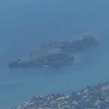
Celeron Island, seen from the northwest in a 2015 aerial photo
_(cropped_to_Celeron_Island).jpg)
