Central Indian Ridge facts for kids
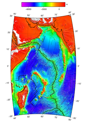
The Central Indian Ridge (CIR) is a long underwater mountain range in the western Indian Ocean. It stretches from north to south, like a seam on the ocean floor. This ridge is where two of Earth's giant plates are slowly pulling apart.
Contents
What is the Central Indian Ridge Like?
The Central Indian Ridge looks like other underwater mountain ranges where the Earth's plates are moving slowly to moderately fast. It has a deep valley in the middle, about 500 to 1000 meters (1,600 to 3,300 feet) deep.
This ridge is made of many segments, each about 50 to 100 kilometers (30 to 60 miles) long. These segments are separated by cracks called transform faults, which are about 30 kilometers (19 miles) long. There are also smaller breaks called non-transform discontinuities.
New molten rock, called magma, comes up from deep inside the Earth. It forms volcanic ridges that are 15 kilometers (9 miles) long and 1 to 2 kilometers (0.6 to 1.2 miles) wide. These ridges rise 100 to 200 meters (330 to 660 feet) above the valley floor.
The plates along the CIR are spreading apart at different speeds. Near the Equator, they move about 30 millimeters (1.2 inches) per year. Closer to the Rodrigues Triple Junction at its southern end, they spread faster, about 49 millimeters (1.9 inches) per year. This makes the CIR an "intermediate" spreading ridge.
Most of the time, the ridge segments are straight compared to the spreading direction. But between 21°S and 18°S, the ridge bends towards the west. Here, the larger cracks (offsets) switch directions. The Mary Celeste Fracture Zone at 18°S is a very long crack, almost 300 kilometers (186 miles) long.
The southern part of the CIR, from the Rodrigues Triple Junction to the Argo Fracture Zone (25°S-13°S), is mostly straight. North of the Argo Fracture Zone, it becomes very angled and has many small ridge segments. The northern part, including the Carlsberg Ridge, runs northwest and does not have many large cracks. The ridge gets deeper as you go south, from 3200 meters (10,500 feet) deep at 20°S to 4000 meters (13,100 feet) deep at the Rodrigues Triple Junction.
Where are the Boundaries?
The Central Indian Ridge is usually seen as the boundary between the African Plate and the Indo-Australian Plate. At its northern end, the Owen Fracture Zone was thought to separate the Indian-Australian plate from the Arabian Plate. However, there's very little movement in the Owen Fracture Zone. This means Arabia and India are actually moving together as one large plate.
This large plate is separated from the Australian Plate by a "diffuse boundary." This means it's not a clear, sharp line. This boundary, called the India–Capricorn boundary, stretches east from the CIR near the Chagos Bank. It then goes to the Ninety East Ridge and north along that ridge to the northern end of the Sunda Trench. Scientists think this fuzzy boundary started forming about 5 to 11 million years ago. It might be linked to the opening of the Gulf of Aden and the rising of the Himalayas mountains.
How the Ridge Formed and Hotspots
The Central Indian Ridge began to form about 38 million years ago. This happened when the Mascarene Plateau and the Chagos-Laccadive Ridge started to separate. Both of these are features created by the Réunion hotspot. A hotspot is a place deep in the Earth where hot molten rock rises to the surface, creating volcanoes. The Réunion hotspot is the only one known to have affected the CIR.
The Réunion hotspot is now about 1100 kilometers (680 miles) away from the CIR. But about 47 million years ago, it crossed the ridge from the Indian Plate to the African Plate. The path of the Réunion hotspot includes the Chagos-Laccadive Ridge on the Indian Plate. This path leads to the west coast of India, where the hotspot created the huge Deccan Traps volcanic area about 66 million years ago.
The only land above water near the CIR is Rodrigues Island. This island is part of the mysterious Rodrigues Triple Junction, located between Mauritius and the CIR. The Rodrigues Ridge reaches the CIR at 19°S through a series of smaller ridges known as the Three Magi. However, the rocks from Rodrigues Island are similar to rocks from Réunion and Mauritius that are 1.3 to 1.58 million years old. This means the Rodrigues Ridge probably didn't start at the CIR itself. The Réunion hotspot is the most likely cause for Rodrigues Island.
See also
 In Spanish: Dorsal Central del Índico para niños
- Southeast Indian Ridge
- Southwest Indian Ridge
 | Selma Burke |
 | Pauline Powell Burns |
 | Frederick J. Brown |
 | Robert Blackburn |


