Cereté facts for kids
Quick facts for kids
Cereté
|
||
|---|---|---|
|
Municipality and town
|
||
|
||

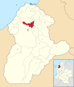
Location of the municipality and town
of Cereté in the Department of Cordoba |
||
| Country | ||
| Department | Cordoba | |
| Founded | 1740 | |
| Incorporated | 1923 | |
| Government | ||
| • Type | Municipality | |
| Area | ||
| • Municipality and town | 290.8 km2 (112.3 sq mi) | |
| • Urban | 19.33 km2 (7.46 sq mi) | |
| Elevation | 12 m (39 ft) | |
| Population
(2020 est.)
|
||
| • Municipality and town | 108,409 | |
| • Density | 372.80/km2 (965.54/sq mi) | |
| • Urban | 60,220 | |
| • Urban density | 3,115.4/km2 (8,068.8/sq mi) | |
| Demonym(s) | Cereteano | |
| Area code(s) | 57 + 4 | |
| Website | Official site: http://www.cerete-cordoba.gov.co | |
Cereté is a lively town and municipality in northern Colombia, located in the Córdoba Department. In 2020, about 108,409 people lived in Cereté and its surrounding areas. It is a significant place in the region.
Contents
What Does the Name Cereté Mean?
The name Cereté comes from two words used by local indigenous people. These words are Chere (meaning fish) and te (meaning shelter). So, Cereté means 'shelter for fish' or 'place of fish'.
A Look at Cereté's History
Cereté has a long history, being one of the oldest settlements in the Sinú Region. It was first settled in 1721 by Spanish explorers Francisco Velásquez and Cristóbal Jiménez de León. Later, in 1731, jesuit priests came to the area to teach and spread their religion among the local indigenous communities. Cereté officially became a village in 1740, thanks to Juan de Torrezal Díaz Pimienta who helped organize the settlement.
Where is Cereté Located?
Cereté is in a great spot in the Córdoba Department. It shares borders with several other towns. To the north, it borders San Pelayo. To the east, you'll find Ciénaga de Oro and San Carlos. To the south, it borders San Carlos and Montería. And to the west, it again borders San Pelayo and Montería. The total area of Cereté is about 351.8 square kilometers.
Climate and Weather in Cereté
Cereté enjoys a warm climate all year round. The average temperature is about 28 degrees Celsius (82 degrees Fahrenheit). The town is located about 12 meters (39 feet) above sea level. Cereté is also quite close to Montería, the capital of the Cordoba Department, being only about 18 kilometers (11 miles) away.
A small river called the Caño Bugre (Bugre Stream) flows through Cereté. This stream is a branch of the larger Sinú River. In the past, the Bugre Stream was important for travel. Boats could use it to connect Cereté with other towns along the river, like Puerto Wilches and San Pelayo.
| Climate data for Cereté (Turipana), elevation 20 m (66 ft), (1981–2010) | |||||||||||||
|---|---|---|---|---|---|---|---|---|---|---|---|---|---|
| Month | Jan | Feb | Mar | Apr | May | Jun | Jul | Aug | Sep | Oct | Nov | Dec | Year |
| Mean daily maximum °C (°F) | 33.4 (92.1) |
33.9 (93.0) |
34.1 (93.4) |
33.6 (92.5) |
32.7 (90.9) |
32.3 (90.1) |
32.5 (90.5) |
32.6 (90.7) |
32.1 (89.8) |
31.9 (89.4) |
32.1 (89.8) |
32.5 (90.5) |
32.8 (91.0) |
| Daily mean °C (°F) | 27.6 (81.7) |
27.9 (82.2) |
28.3 (82.9) |
28.4 (83.1) |
28.1 (82.6) |
27.9 (82.2) |
28.0 (82.4) |
27.8 (82.0) |
27.4 (81.3) |
27.3 (81.1) |
27.3 (81.1) |
27.4 (81.3) |
27.8 (82.0) |
| Mean daily minimum °C (°F) | 22.3 (72.1) |
22.6 (72.7) |
23.2 (73.8) |
23.9 (75.0) |
24.0 (75.2) |
23.7 (74.7) |
23.5 (74.3) |
23.5 (74.3) |
23.3 (73.9) |
23.4 (74.1) |
23.2 (73.8) |
22.9 (73.2) |
23.3 (73.9) |
| Average precipitation mm (inches) | 88.1 (3.47) |
84.5 (3.33) |
98.6 (3.88) |
85.2 (3.35) |
104.9 (4.13) |
139.7 (5.50) |
83.9 (3.30) |
115.8 (4.56) |
125.2 (4.93) |
83.6 (3.29) |
134.9 (5.31) |
143.2 (5.64) |
1,287.5 (50.69) |
| Average precipitation days | 1 | 1 | 3 | 10 | 15 | 15 | 16 | 16 | 15 | 14 | 10 | 5 | 117 |
| Average relative humidity (%) | 79 | 78 | 76 | 78 | 83 | 83 | 83 | 83 | 84 | 84 | 84 | 82 | 81 |
| Mean monthly sunshine hours | 229.4 | 183.5 | 158.1 | 126.0 | 127.1 | 141.0 | 167.4 | 161.2 | 135.0 | 145.7 | 159.0 | 189.1 | 1,922.5 |
| Mean daily sunshine hours | 7.4 | 6.5 | 5.1 | 4.2 | 4.1 | 4.7 | 5.4 | 5.2 | 4.5 | 4.7 | 5.3 | 6.1 | 5.3 |
| Source: Instituto de Hidrologia Meteorologia y Estudios Ambientales | |||||||||||||
How Cereté Makes a Living
The economy of Cereté is mainly based on two important activities. The first is cattle raising, which means raising cows and other livestock. A large area of about 270 square kilometers (104 square miles) is used for this. The second main activity is agriculture, which is farming. Farmers in Cereté grow a lot of cotton, which is sometimes called "white gold" because it's so valuable. They also grow sorghum, another important crop. These crops cover an area of about 80 square kilometers (31 square miles).
See also
 In Spanish: Cereté para niños
 | May Edward Chinn |
 | Rebecca Cole |
 | Alexa Canady |
 | Dorothy Lavinia Brown |


