Chamisal, New Mexico facts for kids
Quick facts for kids
Chamisal, New Mexico
|
|
|---|---|

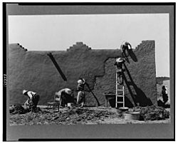
Remudding an adobe wall in Chamisal, circa 1940. Photo: Russell Lee
|
|

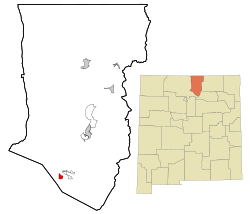
Location of Chamisal, New Mexico
|
|
| Country | United States |
| State | New Mexico |
| County | Taos |
| Area | |
| • Total | 1.64 sq mi (4.25 km2) |
| • Land | 1.64 sq mi (4.25 km2) |
| • Water | 0.00 sq mi (0.00 km2) |
| Elevation | 7,408 ft (2,258 m) |
| Population
(2020)
|
|
| • Total | 255 |
| • Density | 155.39/sq mi (60.01/km2) |
| Time zone | UTC−07:00 (Mountain (MST)) |
| • Summer (DST) | UTC−06:00 (MDT) |
| ZIP Codes |
87521
|
| Area code(s) | Area code 575 |
| FIPS code | 35-14110 |
| GNIS feature ID | 2408009 |
Chamisal is a small community located in Taos County, New Mexico. It is called a census-designated place (CDP) because the government counts its population for official records. Chamisal is found along the beautiful High Road to Taos, a famous scenic route.
This community was started by settlers who received land from the Las Trampas Land Grant way back in 1751.
Chamisal's Location and Size
Chamisal is in New Mexico. It covers a total area of about 1.6 square miles (4.25 square kilometers). All of this area is land.
People of Chamisal
In 2020, about 255 people lived in Chamisal. Back in 2000, there were 301 people living here.
Most of the people in Chamisal are of Hispanic or Latino background.
The population includes people of all ages. In 2000, about a quarter of the people were under 18 years old. Many adults were between 25 and 64 years old. About 16% of the people were 65 years or older.
Education in Chamisal
Students in Chamisal attend schools that are part of the Peñasco Independent School District.
See also
 In Spanish: Chamisal (Nuevo México) para niños
 | Victor J. Glover |
 | Yvonne Cagle |
 | Jeanette Epps |
 | Bernard A. Harris Jr. |


