Chapman River facts for kids
Quick facts for kids Chapman River |
|
|---|---|

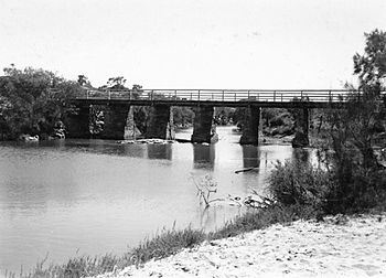
Bridge over the Chapman River, Geraldton, 1946
|
|
| Country | Australia |
| Physical characteristics | |
| Main source | Yuna 270 metres (886 ft) |
| River mouth | Bluff Point |
| Length | 105 kilometres (65 mi) |
| Basin features | |
| Basin size | 1,644 square kilometres (635 sq mi) |
The Chapman River is an important river located in the Mid West area of Western Australia. It flows through beautiful landscapes and plays a role in the local environment.
Contents
Where Does the Chapman River Flow?
The Chapman River starts on the Victoria Plateau, which is east of Northampton. It flows south, passing through the town of Nabawa in the Shire of Chapman Valley. The river continues south until it reaches the area near Geraldton.
From there, it moves down to the flat coastal land. The river then turns towards the west-north-west. Finally, it empties into the Indian Ocean at Bluff Point in Champion Bay. Smaller streams that join the Chapman River include Chapman River East, Skelton Gully, Una Brook, and Rushy Gully.
Understanding the River's Water
The area where the Chapman River collects its water is called its catchment. Most of this 1,160 square kilometer catchment is used for farming. Farmers often use special plant foods called fertilisers on their crops. Sometimes, these fertilisers and loose soil can wash into the river.
This can cause the river water to have high levels of certain substances like nitrogen and phosphorus. When too many of these substances are in the water, it can lead to problems. The river system, especially closer to the ocean, can become less healthy. This is also affected by towns growing closer to the riverbanks.
The Chapman River usually does not flow during the hot summer months. However, it always flows during the winter. Near its mouth, for about 1.5 kilometers upstream, the river is an estuary. An estuary is where fresh river water mixes with salty ocean water. This part of the river always has some water.
The river's mouth is usually blocked by a sandbar. This is a natural barrier of sand. When there is a lot of rain and the river flows strongly, the sandbar opens. This allows river water to flow into the ocean. It also lets some seawater come into the estuary, making it a little salty. The sandbar closes again once the strong flow stops.
During times of very heavy rain, soil can wash into the river. This soil is then carried out to sea. For example, after heavy rains in 1986, it was estimated that the Chapman River carried a huge amount of soil into the ocean. This shows how important it is to protect the land around the river.
Protecting the Chapman River
The areas along the riverbanks are called the riparian zone. These areas are managed as part of the Chapman Regional Wildlife Corridor Project. This project helps to protect the plants and animals that live near the river. Many parts of this zone are also protected by being declared regional parks, such as Spalding Park. These efforts help keep the river and its surroundings healthy for everyone.
History of the River's Name
The Chapman River was given its name on April 7, 1839. This happened during an expedition led by an explorer named George Grey. He was on his second journey along the coast of Western Australia.
The river was likely named after John Chapman. At that time, John Chapman was the deputy chairman of the Western Australian Company. Later, he became a British Member of Parliament (MP). He was also a business partner of Grey's friend, Sir William Hutt. Grey had named the nearby Hutt River after Sir William Hutt just two days before.
 | Shirley Ann Jackson |
 | Garett Morgan |
 | J. Ernest Wilkins Jr. |
 | Elijah McCoy |

