Chatanika, Alaska facts for kids
Quick facts for kids
Chatanika, Alaska
|
|
|---|---|

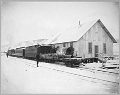
Train of the Tanana Valley Railroad at the station in Chatanika, Alaska, 1916
|
|
| Country | United States |
| State | Alaska |
| Borough | Fairbanks North Star |
| Township | T N R W Meridian |
| Settled | 1904 |
| Named for | Chatanika River |
| Elevation | 896 ft (273 m) |
| Time zone | UTC-9 (Alaska (AKST)) |
| • Summer (DST) | UTC-8 (AKDT) |
| ZIP code |
99712
|
| Area code | 907 (local exchange phones use the 389 prefix) |
| FIPS code | 02-12460 |
| GNIS feature ID | 1400167 |
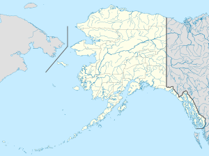
Chatanika is a small community in Alaska, United States. It is located north of the city of Fairbanks. The community stretches for about 20 miles (32 km) along the Steese Highway. This highway often runs right next to the Chatanika River.
In Chatanika, you can find scattered homes and a few businesses. There's also a boat launch where the highway crosses the river. You might see old equipment from past gold mining operations. Chatanika is also home to the Poker Flat Research Range. This is a special place run by the University of Alaska Fairbanks where scientists study the Earth's atmosphere.
Chatanika was one of many small towns near Fairbanks. Its success was linked to gold mining during the Fairbanks Gold Rush. Chatanika was also important because it was the end point for the Tanana Valley Railroad. This railroad helped move supplies and gold related to mining. Today, Chatanika and Fox are two of the few old mining towns that are still populated.
Contents
History of Chatanika
Early Settlement and Railroad
Chatanika started as a mining settlement around 1904. It grew when the Tanana Valley Railroad was finished in 1907. This railroad connected Chatanika to other areas. A post office was opened in Chatanika in 1908.
Population and Name
Community Population Over Time
| Historical population | |||
|---|---|---|---|
| Census | Pop. | %± | |
| 1910 | 193 | — | |
| 1930 | 63 | — | |
| 1940 | 106 | 68.3% | |
| U.S. Decennial Census | |||
Chatanika first appeared in the U.S. Census in 1910. At that time, 193 people lived there. It was not counted in the 1920 census. In 1930, it appeared again as "Chatanika River," but the name went back to Chatanika in 1940. It has not been listed in the census since 2010.
Meaning of the Name
The community of Chatanika was named after the nearby Chatanika River.
Geography of Chatanika
Chatanika is located about 2 miles (3 km) east of where Cleary Creek meets the Chatanika River. It is about 20 miles (32 km) northeast of Fairbanks. The community sits at an elevation of 896 feet (273 meters) above sea level.
The Chatanika Gold Dredge
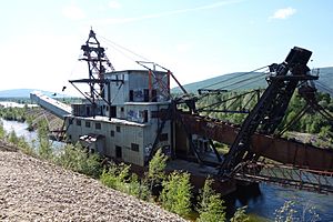
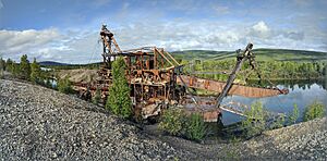
The Chatanika gold dredge was a historic machine. It was known as gold dredge #3. The F.E. Company owned and operated it from 1928 to 1958. This dredge was used to dig for gold.
The dredge was located about 27.5 miles (44 km) along the Steese Highway. It sat in a 60-acre pond that it had dug itself. This pond was directly across the road from the Chatanika Lodge. The dredge was on private property, so people could not visit it. Sadly, an accidental fire destroyed the dredge in August 2013.
See also
 In Spanish: Chatanika (Alaska) para niños
 | William M. Jackson |
 | Juan E. Gilbert |
 | Neil deGrasse Tyson |


