Chennai district facts for kids
The Chennai district, once called Madras district, is a special part of Tamil Nadu state in India. Even though it's the smallest district in Tamil Nadu, it has the most people living in it! Most of the big city area of Chennai is part of this district.
Contents
Who Lives in Chennai District?
Population and People
In 2011, a count showed that about 4,646,732 people lived in Chennai district. This number included 2,335,844 males and 2,310,888 females. Most people here can read and write, with a literacy rate of over 90%.
The district is very crowded! About 26,553 people live in every square kilometer. This is called population density. For every 1,000 males, there are 989 females. This is known as the sex ratio.
How Chennai District is Managed
Local Areas Called Taluks
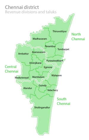
To help manage the district, Chennai is split into smaller parts called taluks. These divisions make it easier to run the district and provide services to everyone. Here are some of the taluks:
- Aminjikarai taluk
- Ayanavaram taluk
- Egmore taluk
- Guindy taluk
- Mambalam taluk
- Mylapore taluk
- Perambur taluk
- Tondiarpet taluk
- Purasaiwalkam taluk
- Velachery taluk
- Sholinganallur taluk
- Tambaram taluk
- Madhavaram taluk
Where is Chennai District Located?
Land and Water Features
The Chennai district covers an area of about 178.8 square kilometers. It is located on the Coromandel Coast, which is a part of the Bay of Bengal.
A small part of the district, about 2.71 square kilometers, is covered by the Guindy National Park. This is a protected forest area. The district also has several waterways, including the Cooum River, Adyar River, Buckingham Canal, and the Otteri Nullah stream.
See also
 In Spanish: Distrito de Chennai para niños
 | Tommie Smith |
 | Simone Manuel |
 | Shani Davis |
 | Simone Biles |
 | Alice Coachman |


