Cherokee, Nevada County, California facts for kids
Quick facts for kids
Cherokee
|
|
|---|---|
|
Former settlement
|
|
| Country | |
| State | |
| County | Nevada County |
| Elevation | 2,516 ft (767 m) |
Cherokee is a former gold mining town in Nevada County, California. It was also known by other names like Patterson, Melrose, and Tyler. The town is located on the San Juan Ridge, about 4 miles east of North San Juan. It sits about 2,516 feet (767 meters) above sea level.
Contents
History of Cherokee
The San Juan Ridge is a long area, about 30 miles (48 kilometers) long. It lies between the south and middle forks of the Yuba River. This ridge was built on an ancient riverbed filled with gold-rich gravel. This made it one of California's most important mining areas in the late 1800s.
Archaeologists have found signs that people lived on the Ridge, including the Cherokee area, as far back as 5,000 years ago. When the California Gold Rush began, the Nisenan or Southern Maidu people lived there. They had been living in different spots along the Ridge for over a thousand years.
The Gold Rush Arrives
The Gold Rush came to Cherokee in 1850. A group of Cherokee Indians started mining there, giving the place its name. In 1851, two miners, Crego and Utter, built a home in the area. Mining here was very successful. The town quickly grew, especially after the Grizzly Ditch brought water all year for mining. By 1852, about 400 people lived in Cherokee. For a while, it was the busiest mining spot on the Ridge.
Cherokee's Busy Years
Cherokee's best years were between 1856 and 1865. The town had two hotels, the Grizzly and Curnow’s. There were also saloons, several stores, a butcher, and a shoe shop. A doctor and a blacksmith also worked there. The local newspaper was called the Cherokee Journal.
The town's sawmill could produce 10,000 feet of lumber every day. Stagecoaches offered rides to Nevada City. After 1878, Cherokee was connected to the world’s first long-distance telephone line. This line ran from French Corral to the Bowman Lake area.
In 1860, a reporter visited Cherokee and wrote about it. He noted that new buildings had appeared. Gardens and orchards were growing on the edges of town. He said that mining was still happening, but the town might not be as promising for gold as before.
Community Life and Education
A public school was built in 1855. People paid for it themselves. In 1858, 83 children went to the school. By 1861, this number grew to 107 students. A new schoolhouse was built in 1872. It had a small library next to it. By 1879, the number of students had dropped to 73.
The town also had a Catholic church with many members. Other religious groups held their services in the schoolhouse.
Changing Names and the Post Office
A post office opened in Cherokee in 1855. However, there was already another California post office named Cherokee in Butte County. So, the town voted to change its name to Patterson. This honored James Patterson, a local citizen and acting County Clerk.
The post office closed in 1895. It reopened in 1905 but closed again in 1909. It briefly reopened in 1910 under the name Melrose. This was the Massachusetts hometown of the postmaster, James L. Morgan. In 1911, the name changed to Tyler. This is the name still seen on the highway sign at the intersection of Highway 49 and Tyler Foote Crossing Road. The post office closed for good in 1924. Even with all these official name changes, local people usually still called the town Cherokee. This name appears on many maps from that time.
The Grizzly Hotel
A famous building in town was the Grizzly Hotel. The Turney family built it in 1852. A local newspaper in 1854 called it "one of the pleasantest homes for miners or travellers." The hotel had a public hall. This hall was often used for dances and parties, like Fourth of July celebrations.
In 1867, Mrs. Turney took over the hotel from her husband. She renamed it the Cherokee Hotel. In 1871, a fire destroyed the Cherokee Hotel and its saloon.
Mining Decline
Mining in Cherokee was not as promising as in some nearby towns, like North Bloomfield. The main mine was the Manzanita Mine. It was owned by the Milton Mining and Water Company. This company owned many other mines and water systems on the San Juan Ridge. Even as mining slowed down, the Manzanita Mine still produced almost $174,000 in gold in 1878.
As gold mining decreased, the town also got smaller. By 1880, the population had dropped to about 200 people. In 1895, someone noted that "the town is quiet" because hydraulic mining had been stopped. A few years before, the U.S. Army had estimated that 10 million cubic yards of gold-bearing gravel had been dug up in the Cherokee area. They believed 33 million cubic yards still remained.
Some mining continued around Cherokee even during World War I. The Guggenheim family was thought to be funding some of it. In 1924, a historian wrote that the town was down to "one store." He added that people mainly lived by farming, and very little active mining was happening there.
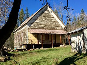
Today, only a few things remain of Cherokee. These include the old schoolhouse, which is on Sages Road north of Tyler Foote Crossing Road. There is also a historic cemetery. Much of the land is still marked by the effects of hydraulic mining. However, a spiritual community called Ananda Village has grown up northwest of the old town site.
 | Claudette Colvin |
 | Myrlie Evers-Williams |
 | Alberta Odell Jones |


