
Chysauster Ancient Village facts for kids

Rooms in a building within Chysauster village
|
|

Location in Southwest Cornwall
|
|
| Location | New Mill, Cornwall |
|---|---|
| Coordinates | 50°09′40″N 5°32′25″W / 50.16103°N 5.54022°W |
| Type | Ancient village |
| History | |
| Founded | c. 100 BC |
| Abandoned | c. 300 AD |
| Periods | Iron Age/Roman |
| Cultures | Romano-British |
| Site notes | |
| Condition | Ruins |
| Ownership | English Heritage |
| Public access | Yes |
Chysauster Ancient Village is a really old village in Cornwall, United Kingdom. It was built during the late Iron Age and was still used when the Romans were in Britain. The name Chysauster comes from the Cornish words Chisylvester, which means Sylvester's house.
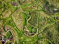
This village is special because it has unique "courtyard houses." These are homes built around an open central space. There were about eight to ten of these houses in the village. You can also find the remains of a fogou, which is a mysterious underground passage, nearby. Today, English Heritage looks after Chysauster, so people can visit and learn about it.
Contents
Where is Chysauster Village?
Chysauster is located in the southwest part of Cornwall, in an area called Penwith. It's about 5 kilometers (3 miles) north of Penzance. The village sits on a hill, about 175 meters (574 feet) above sea level.
You can visit Chysauster from spring (March/April) until early winter (November). English Heritage manages the site and there is a small fee to enter. Not far from Chysauster, about 1 kilometer (0.6 miles) to the east, is another ancient site called Castle An Dinas. This was an Iron Age hill fort.
Life in the Ancient Village


People lived in Chysauster Ancient Village for a long time, from about 100 BC until the 3rd century AD. The villagers were mostly farmers. The village was not built with strong defenses, which suggests it was a peaceful farming community. It was likely home to members of the Dumnonii tribe, who lived in this part of Britain.
The village has the remains of about 10 courtyard houses. Each house was quite large, around 30 meters (98 feet) across. Most of these houses are lined up in two rows. Every house had an open space in the middle, like a small yard. Around this yard were several rooms with thatched roofs. All the houses were built in a similar way, usually facing east. Some of the stone walls still stand as tall as 3 meters (10 feet) today! You can also see signs of old farm fields nearby, showing how important farming was to the people here.
Chysauster has been studied many times by archaeologists. One of the first people to dig here was William Copeland Borlase in 1873. Over the years, some parts of the village have been rebuilt to help protect them and show visitors what they might have looked like.
The Mysterious Fogou
To the south of the village, there's an underground passage called a fogou. This word comes from the Cornish language and means "cave." Fogous are found in other places in the UK and Ireland, where they are also known as souterrains. No one is completely sure what these underground tunnels were used for. Some think they were for storage, others for shelter, or even for ceremonies.
The fogou at Chysauster was once over 16 meters (52 feet) long. However, it was blocked up in the late 1900s to keep visitors safe. An early description of it from around 1847 by Henry Crozier called it a "sepulchral chamber," suggesting he thought it might have been a burial place.
Images for kids
-
Looking over the top of Chysauster Ancient Village
-
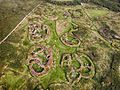
An aerial view of Chysauster Ancient Village


