Chíllar River facts for kids
Quick facts for kids Chíllar River |
|
|---|---|

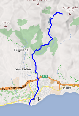
Cours of the Chillar
|
|
| Other name(s) | Cahorros |
| Country | Spain |
| Autonomous community | Andalusia |
| Province | Málaga |
| Municipality | Cómpeta, Frigiliana and Nerja |
| Physical characteristics | |
| Main source | Sierra de Almijara 1,761 metres (5,778 ft) |
| River mouth | Mediterranean Sea 0 metres (0 ft) 36°44′31″N 3°53′15″W / 36.741948°N 3.887488°W |
| Length | 17 kilometres (11 mi) |
| Basin features | |
| Basin size | 54 square kilometres (21 sq mi) |
| Tributaries |
|
The Chíllar River is a cool river in the east of Málaga Province, Spain. It starts high up in the Sierra de Almijara mountains. The river then flows all the way down to the Mediterranean Sea, right near the town of Nerja. Many people love to walk along this river, especially in summer!
Contents
About the Chíllar River
Most of the Chíllar River flows through a special protected area. This area is called the Sierras of Tejeda, Almijara and Alhama Natural Park. It is always open for people to visit and explore.
The river's water comes from a large area of land. This area is called its catchment area. For the Chíllar River, this area is about 54 square kilometers (21 square miles). The river carries about 0.2 cubic meters (7 cubic feet) of water every second.
The Chíllar River starts very high up, at about 1,761 meters (5,778 feet) above sea level. It then flows all the way down to the sea. The rocks around the river are mostly limestone, which is a soft type of rock. The river has slowly carved out a deep canyon through these rocks over many years.
In 1997, the town of Nerja started a plan to keep the lower part of the river clean. They wanted to stop trash and building waste from being dumped there. This way, more people could enjoy the river for fun activities.
Walking the Chíllar River
One of the most popular things to do at the Chíllar River is to walk up it. This adventure usually starts on an asphalt road called "los Almachares." This road goes under the A-7 motorway and past a concrete factory. It then turns into a gravel path that leads to the entrance of the natural park.
The River Path
Once you are in the park, the path often goes right along the riverbed. The water is usually only ankle-deep. Sometimes, it might be a bit deeper, up to about a foot (30 centimeters). It is a great way to cool off on a hot day!
About 4 kilometers (2.5 miles) into the park, the river flows through some very narrow spots. These are like small canyons, only about 1 meter (3 feet) wide. But they are more than 20 meters (65 feet) deep! Walking through these narrow parts is a really exciting experience.
Vado de Los Patos
Further up the river, about 8 kilometers (5 miles) from the start, you will find a place called "Vado de Los Patos." This means "Duck's Ford." Here, a small waterfall feeds into a pool of water. It is a perfect spot to stop for a swim and relax.
Going past Vado de Los Patos can be a bit harder. About 2 kilometers (1.2 miles) higher up, you will reach "La Presa." This is a dam that holds back water in a reservoir. The water from this reservoir is used to water crops in the valley nearby.
See also
 In Spanish: Chíllar para niños
 | Percy Lavon Julian |
 | Katherine Johnson |
 | George Washington Carver |
 | Annie Easley |

