Sierra de Almijara facts for kids
Quick facts for kids Sierra de Almijara |
|
|---|---|

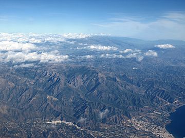
Sierra de Almijara with Sierra Nevada in the background
|
|
| Highest point | |
| Peak | Navachica |
| Elevation | 1,831 m (6,007 ft) |
| Geography | |
| Country | Spain |
| Parent range | Penibaetic System |
| Geology | |
| Type of rock | Calcareous formations |
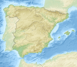
The Sierra de Almijara is a mountain range found in southern Spain. It stretches across two provinces: Granada and Málaga. The mountains are mostly made of a type of rock called marble. This gives the narrow peaks and deep valleys a white or gray color.
Most of this mountain range is a protected area. It is part of the Sierras of Tejeda, Almijara and Alhama Natural Park. This park helps to keep the natural beauty and wildlife safe.
Contents
Where is the Sierra de Almijara?
The Sierra de Almijara is connected to the Tejeda mountains. Together, they form one long mountain range. This range is about 40 kilometers (25 miles) west of the famous Sierra Nevada.
These mountains act like a big wall. They separate the warm coast from the cooler areas further inland. They are also part of a larger mountain system called the Penibaetic System.
The Natural Park: A Protected Area
The Sierras of Tejeda, Almijara and Alhama Natural Park is very large. It covers about 40,657 hectares (100,465 acres). This park includes both the Sierra de Tejeda and Sierra de Almijara mountains.
It stretches across two regions, or comarcas. One is the Axarquía region in eastern Málaga province. The other is the Alhama region in southwestern Granada province.
What do the Almijara Mountains Look Like?
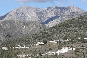
The Sierra de Almijara is a rugged area. It has many marble mountains with sharp, rocky ridges. These ridges stretch out to the east from a place called Puerto de Cómpeta.
The mountains have narrow peaks. Deep valleys are cut through them by streams and rivers. This creates many smaller river areas. The most noticeable peak is the Cerro del Lucero.
The highest point in the Sierra de Almijara is Navachica. This peak reaches a height of 1,831 meters (6,007 feet) above sea level. It stands out by 597 meters (1,959 feet) from the land around it.
The Sierra Almijara and Sierra Tejeda mountains form the southern edge of the western Granada basin. Rivers like the Cacín River get their water from these mountains.
Weather in the Mountains
The mountains get the most rain in December, January, and March. July is usually the driest month. The amount of rain changes across the area. Some places like Cacín get about 400 millimeters (16 inches) of rain each year. Other areas, like Arenas del Rey, can get up to 1,000 millimeters (39 inches).
Temperatures
Near the coast, in towns like Nerja and Almuñecar, temperatures usually range from 4°C (39°F) to 30°C (86°F). Higher up in the mountains, it's cooler. Temperatures there range from 0°C (32°F) to 22°C (72°F). Further inland, in the Alhama region, it can get colder in winter and much hotter in summer. Temperatures can range from -3.1°C (26.4°F) to 40°C (104°F).
At lower and middle heights, the climate is semi-dry Mediterranean. This means it's warm and dry for much of the year. The average air temperature is between 17°C and 19°C (63-66°F). The average rainfall is 350-600 millimeters (14-24 inches) per year. Most of this rain falls heavily between November and March.
Geology: What the Mountains are Made Of
The entire park area has calcareous formations. This means the rocks are rich in calcium carbonate. You can find rocks like marbles, shales, and phyllites here. The area also has a lot of quartzite and gneiss, which are very old rocks, over 300 million years old.
The Sierra de Almijara is one of Spain's main sources of dolomitic marble. This marble gives the mountain ridges and valleys their white and gray colors.
Caves and Canyons
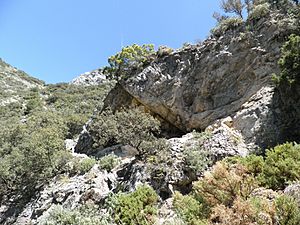
Over time, water has worn away the limestone rock. This has created a network of cracks, dips, and caves. One example is the deep canyon of the Chíllar River. Another famous example is the Caves of Nerja.
The Caves of Nerja (Cueva de Nerja) are a National Monument. Their entrance is just south of the park.
The main rock in the area is dolomite marble. It formed during the Triassic period. This rock has been folded and broken by cracks over millions of years. In some places, the rock has weathered into sands of almost pure dolomite crystals. This means the soil often has high levels of carbonates and magnesium, but not many plant nutrients.
Because the slopes are steep, there isn't much plant life. This, along with fires, means the soil doesn't develop very well.
Important Peaks
Here are some of the named peaks in the Sierra de Almijara, listed from west to east:
| Name | Height | Coordinates |
|---|---|---|
| Santiago | 1,645 m (5,397 ft) | |
| Malas Camas | 1,791 m (5,876 ft) | |
| Abucaz | 1,726 m (5,663 ft) | |
| Rajas Negras | 1,641 m (5,384 ft) | |
| Frailes | 1,669 m (5,476 ft) | |
| Arca Catete | 1,664 m (5,459 ft) | |
| Mota | 1,649 m (5,410 ft) | |
| Venta Panaderos | 1,687 m (5,535 ft) | |
| Lucero or Moriscos | 1,774 m (5,820 ft) | 36°52′03″N 3°53′26″W / 36.867537°N 3.890464°W |
| Los Machos | 1,589 m (5,213 ft) | 36°51′37″N 3°52′19″W / 36.860346°N 3.871972°W |
| La Cadena | 1,645 m (5,397 ft) | 36°51′14″N 3°51′23″W / 36.853917°N 3.856445°W |
| Salto del Caballo | 1,642 m (5,387 ft) | |
| Piedra Sellada | 1,679 m (5,508 ft) | |
| Cabañeros | 1,712 m (5,617 ft) | 36°51′33″N 3°48′52″W / 36.859138°N 3.814517°W |
| Navachica | 1,831 m (6,007 ft) | 36°50′31″N 3°48′55″W / 36.841917°N 3.815306°W |
See also
 In Spanish: Sierra de Almijara para niños
 | Kyle Baker |
 | Joseph Yoakum |
 | Laura Wheeler Waring |
 | Henry Ossawa Tanner |


