Sierra de Tejeda facts for kids
Quick facts for kids Sierra de Tejeda |
|
|---|---|
 |
|
| Highest point | |
| Peak | La Maroma |
| Elevation | 2,066 m (6,778 ft) |
| Naming | |
| Etymology | The name "Tejeda'" refers to the abundance of Taxus baccata (yew) trees in the past. |
| Geography | |
| Country | Spain |
| Geology | |
| Age of rock | 300 million years |
| Type of rock | Calcareous formations |
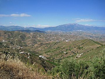
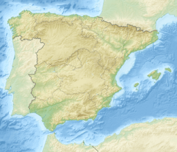
The Sierra de Tejeda is a mountain range in southern Spain. It is part of the Penibaetic System of mountains. This range stretches between the provinces of Málaga and Granada.
Along with the Sierra de Almijara to the east and the Sierra de Alhama to the west, it forms a large limestone area. This area acts like a natural wall between the two provinces. It separates the Axarquía region from the depression of Granada. These mountains are also home to the Sierras of Tejeda, Almijara and Alhama Natural Park.
Contents
Where is the Sierra de Tejeda?
The Sierra de Tejeda is a mountain range that runs from northwest to southeast. It is located in the eastern part of Málaga and the southwestern part of Granada. The range covers an area of about 6,755 square kilometres (2,608 sq mi).
It sits southeast of the Sierra de Alhama and northwest of the Sierra de Almijara. The Sierras of Tejeda and Almijara together form a single range. This range is about 40 kilometres (25 mi) west of the famous Sierra Nevada. These mountains create a natural barrier between the coast and the inland areas.
The name "Tejeda'" comes from the many Taxus baccata trees, also known as tejos or yew trees, that used to grow here. Today, only a few of these ancient trees remain. You can find some on La Maroma, including one near the peak at Salto del Caballo. A small group also grows in the upper part of the Barranco del Cañuelo, close to the town of Alcaucín.
How the Mountains Were Formed
The Sierra de Tejeda is in the central part of the Betic Range in Southern Spain. The rocks here are mostly limestone. These rocks are part of the Alpujarride complex. They include layers of rock up to 30 metres (98 ft) thick. These layers formed during the Middle and Late Miocene periods. They contain materials like pebbles, sand, and even large marble rocks up to 1 metre (3 ft 3 in) wide.
The Sierra Almijara and Sierra Tejeda form the southern edge of the western depression of Granada. Rivers like the Cacín River have their beginnings here. Sediments from the Pliocene period, found in the northwest of the Granada basin, were carried down by the Cacín River from these mountains.
In 1884, a strong earthquake, estimated at magnitude 6.5, happened in this region. The earthquake's center was on the northern side of the Sierra Tejeda. Geologists believe it was caused by movement along the natural breaks, or faults, in the Earth's crust that surround the Tejeda and Almijara mountains.
La Maroma: The Highest Peak
The highest point in the Sierra de Tejeda is called La Maroma. It stands tall at 2,065 metres (6,775 ft). From its peak, you can see amazing views of the mountains around it and the Mediterranean coast. La Maroma is also known as the "roof of Málaga" because it is the highest point in the province.
The name "La Maroma" comes from a large, deep hole near the top of the mountain. In the past, people used ropes (called maromas in Spanish) to climb down into this hole. They would collect snow from inside it.
You can climb La Maroma using several paths. The most common route starts from the center of Canillas de Aceituno. Other paths begin from the Alcázar recreational area and from Llanadas de Sedella, which is in the town of Alcaucín. One of the easiest ways to reach the top is from the north side, starting from the El Robledal recreational area in Alhama de Granada.
Weather in the Mountains
These mountains get a good amount of rain. The most rain falls in December, January, and March. July is usually the driest month. For example, in Alcaucín, the yearly rainfall is about 1,000 millimetres (39 in). At an altitude of 1,700 metres (5,600 ft), the average yearly rainfall is a bit more than 900 millimetres (35 in). On average, the Sierra de Tejeda receives about 8.6 cubic hectometres (300,000,000 cu ft) of rain each year.
The average yearly temperature at the Pantano de los Bermejales station, which is at the base of the Sierra, is about 8 °C (46 °F). Higher up in the mountains, temperatures can range from 0 to 22 °C (32 to 72 °F). The plants that grow here are mostly those that can live in dry conditions. Many plant types found in the western Sierra Nevada also grow in the Tejeda and Almijara ranges. This suggests they might have spread between these areas.
People and History
Ancient humans, called early hominids, likely moved between caves on the coast and caves in the Sierra de Tejeda depending on the season. Bones of a Neanderthal man, about 40,000 years old, were found in the Boquete de Zafarraya cave. This cave is in Alcaucín, just west of the Sierra de Tejeda.
Canillas de Aceituno is a town at the foot of the Sierra, at an altitude of 649 metres (2,129 ft). It sits between the marble rocks of the Sierra de Tejeda and the lower, flatter land of the Almanchares river basin.
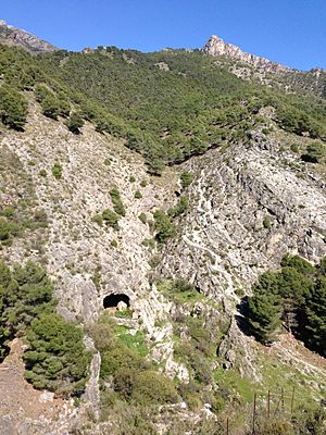
The Fajara cave was used during the Neolithic period, which was a very long time ago. The Rábita cave shows signs that iron ore was mined there during Roman times. There are also three old bridges on the slopes of the sierra, in the towns of Sedella, Salares, and Canillas de Albaida. People say these bridges were built by the Romans, even though they look more like medieval bridges today.
See also
 In Spanish: Sierra de Tejeda para niños
 | Misty Copeland |
 | Raven Wilkinson |
 | Debra Austin |
 | Aesha Ash |


