Canillas de Aceituno facts for kids
Quick facts for kids
Canillas de Aceituno
|
|||
|---|---|---|---|
 |
|||
|
|||
| Sovereign state | |||
| Autonomous community | |||
| Province | |||
| Comarca | Axarquía | ||
| Area | |||
| • Total | 42 km2 (16 sq mi) | ||
| Elevation | 649 m (2,129 ft) | ||
| Population
(2018)
|
|||
| • Total | 1,620 | ||
| • Density | 38.6/km2 (99.9/sq mi) | ||
| Demonym(s) | Canillero | ||
| Time zone | UTC+1 (CET) | ||
| • Summer (DST) | UTC+2 (CEST) | ||
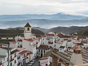
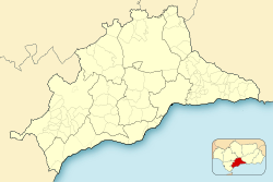
Canillas de Aceituno is a charming village located in southern Spain. It's part of the province of Málaga in the region of Andalusia. This small town sits right at the foot of the "La Maroma" mountains.
The village is about 524 meters (1,719 feet) above sea level. Above it rises La Maroma, the highest peak in the province, reaching 2,068 meters (6,785 feet). Canillas de Aceituno is known for its narrow, whitewashed streets. You'll also see beautiful Moorish arches and lovely flower-filled corners.
The people who live here are called canilleros. Many of them work within the village itself. Their main jobs are in construction and farming. You can find shops in Canillas de Aceituno to buy everyday items. The village is about 61 kilometers (38 miles) from the city of Málaga. You can reach it by highway C-335 and local road M-125 from Vélez-Málaga.
| Top - 0-9 A B C D E F G H I J K L M N O P Q R S T U V W X Y Z |
Exploring Canillas de Aceituno's Nature
Canillas de Aceituno is like a natural viewpoint for the Axarquía region. It is located next to the Sierras of Tejeda, Almijara and Alhama Natural Park in the north.
Scenic Views and Greenery
The road leading to the village offers amazing views. You can see the Velez and Rubite valleys. The landscape is full of olive trees, vineyards, almond trees, and fig trees. On the hills, you might spot large awnings. These are used to dry grapes to make raisins.
Rivers and Springs
Three rivers, the Almanchares, Bermuza, and Rubite, help keep the area green. They also create natural springs like the Gazuela and the Ivy. The area around Canillas de Aceituno has many natural caves. One famous cave is the Fajara, about four kilometers from the village. Inside, its tunnels stretch for about one and a half kilometers.
Village Water Sources
Within the village, there are two natural springs. They get their water from an old Arab cistern. This cistern is located right under the city council building.
Village History and Old Streets
Canillas de Aceituno has some interesting old streets. Castillo street, for example, still has parts of an ancient fortress. This street leads to a lower neighborhood through Estación street. Cemetery street is built over what used to be an old Arab cemetery.
In 1884, an earthquake caused some damage to the village. About 15% of the houses collapsed, and 65% were badly damaged.
What Does the Name Canillas de Aceituno Mean?
The name of the village has two parts. "Cannillae" comes from Latin. It means "the zone of cane plantations." "Azeytuni" is an Arab word. It refers to "woven and dyed silks." So, the name tells us a bit about the village's past.
Life in Canillas de Aceituno
The municipality of Canillas de Aceituno covers an area of 42 square kilometers (16 square miles). The main part of the village is 645 meters (2,116 feet) above sea level. The average temperature here is about 17 degrees Celsius (63 degrees Fahrenheit) each year. The village has a population of about 2,300 people.
See also
 In Spanish: Canillas de Aceituno para niños
 | Sharif Bey |
 | Hale Woodruff |
 | Richmond Barthé |
 | Purvis Young |


