
Cilleruelo de Abajo facts for kids
Quick facts for kids
Cilleruelo de Abajo
|
|||
|---|---|---|---|

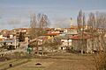
View of Cilleruelo de Abajo, 2010
|
|||
|
|||
| Country | Spain | ||
| Autonomous community | |||
| Province | |||
| Comarca | Arlanza | ||
| Area | |||
| • Total | 48 km2 (19 sq mi) | ||
| Elevation | 965 m (3,166 ft) | ||
| Population
(2018)
|
|||
| • Total | 224 | ||
| • Density | 4.67/km2 (12.09/sq mi) | ||
| Time zone | UTC+1 (CET) | ||
| • Summer (DST) | UTC+2 (CEST) | ||
| Postal code |
09349
|
||
| Website | http://www.cilleruelodeabajo.es/ | ||


Cilleruelo de Abajo is a small town, also called a municipality, located in Spain. It's part of the province of Burgos, which is in the Castile and León region. In 2004, about 298 people lived there. By 2018, the population was 224.
Contents
About Cilleruelo de Abajo
Cilleruelo de Abajo is a quiet place in the Spanish countryside. It's known for its peaceful atmosphere. The town is located in the Arlanza area.
Where is Cilleruelo de Abajo?
This municipality is found in the northern part of Spain. It's in the province of Burgos. This province is part of the larger Castile and León region.
How many people live there?
The number of people living in Cilleruelo de Abajo has changed over time. In 2004, a count showed there were 298 residents. By 2018, the population was recorded as 224 people.
What is a municipality?
A municipality is like a town or a small city. It has its own local government. This government helps manage things like local services and rules for the people living there.
Geography and Location
Cilleruelo de Abajo covers an area of about 48 square kilometers. It sits at an elevation of 965 meters above sea level. This means it's quite high up!
Time Zone Information
Like much of Spain, Cilleruelo de Abajo uses CET. This is UTC+1. During the summer, they switch to CEST, which is UTC+2. This is also known as Daylight Saving Time.
Images for kids
-
A view of Cilleruelo de Abajo in 2010.
See also
 In Spanish: Cilleruelo de Abajo para niños
