Cirueña facts for kids
Quick facts for kids
Cirueña
|
|
|---|---|

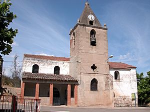
Church of San Andrés
|
|
| Country | Spain |
| Autonomous community | La Rioja |
| Comarca | Santo Domingo de la Calzada |
| Area | |
| • Total | 12.15 km2 (4.69 sq mi) |
| Elevation | 755 m (2,477 ft) |
| Population
(2018)
|
|
| • Total | 142 |
| Demonym(s) | cirueño, ña |
| Postal code |
26258
|
Cirueña is a small village located in the beautiful region of La Rioja, Spain. It's a quiet place, perfect for exploring Spanish village life. The village is part of a larger area called a municipality, which covers about 12.15 square kilometers. In 2018, about 142 people lived there.
Contents
Discovering Cirueña
Cirueña is a charming village in northern Spain. It sits in the Santo Domingo de la Calzada area. This region is known for its lovely landscapes.
What is a Municipality?
A municipality is like a local government area. It includes a town or village and the land around it. Cirueña is a municipality, meaning it has its own local leaders.
Who Leads Cirueña?
The leader of Cirueña is called the Mayor. The current mayor is Pedro Jesús Cañas Martínez. He belongs to a political group called the PP. The mayor helps make decisions for the village.
Life in Cirueña
Cirueña is a peaceful place. It has a traditional Spanish feel. The village is surrounded by nature. This makes it a great spot for outdoor activities.
The Church of San Andrés
One important building in Cirueña is the Church of San Andrés. You can see a picture of it in the infobox. Churches like this are often very old. They are important parts of a village's history.
Where is Cirueña Located?
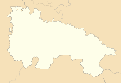
Cirueña is in the La Rioja region of Spain. La Rioja is famous for its delicious food and beautiful countryside. It's in the northern part of Spain.
Getting There
Cirueña has its own postal code, which is 26258. This helps mail get to the right place. You can also visit the village's official website to learn more.
See also
 In Spanish: Cirueña para niños
 | Victor J. Glover |
 | Yvonne Cagle |
 | Jeanette Epps |
 | Bernard A. Harris Jr. |


