Ciudad Nicolás Romero facts for kids
Quick facts for kids
Nicolás Romero
|
|
|---|---|
|
City and municipality
|
|

San Ildefonso, Ciudad Nicolás Romero
|
|
| Country | |
| State | |
| Region | Naucalpan |
| Metro area | Greater Mexico City |
| Municipal Status | June 29, 1820 |
| Municipal Seat | Villa Nicolás Romero |
| Government | |
| • Type | Ayuntamiento |
| Area | |
| • Land | 235.65 km2 (90.98 sq mi) |
| • Water | 0.46 km2 (0.18 sq mi) |
| Elevation
(of seat)
|
2,390 m (7,840 ft) |
| Population
(2010)
|
|
| • Municipality | 366,602 |
| Time zone | UTC-6 (CST) |
| • Summer (DST) | UTC-5 (CDT) |
| Postal code (of seat) |
54400
|
| Area code(s) | 55 |
| Demonym | Nicolásromerense |
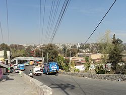
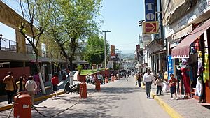
Ciudad Nicolás Romero is a large city and the main town (called the "municipal seat") of the Nicolás Romero municipality in the State of Mexico, Mexico. It is about 58 kilometers (36 miles) from Toluca, which is the capital city of the state. Nicolás Romero is located in the north-central part of the state, just northwest of Mexico City.
The city and municipality are named after Nicolás Romero. He was a brave soldier who fought alongside Benito Juárez during the Reform War and when France tried to take over Mexico. He was sadly executed there by the French. The town was given his name in 1898 to honor him.
Long ago, the area was settled by the Otomi. The Aztecs later conquered it and called it Azcapotzaltongo, which means "among the ant hills" in their Náhuatl language. During the time when Spain ruled Mexico, it was known as San Pedro Azcapotzaltongo. From 1821 to 1898, it was called Monte Bajo before getting its current name.
Contents
Exploring Ciudad Nicolás Romero
How the City Grew
Industrialization, which means building factories and making things, started here in the mid-1800s. Some of the first factories were textile (cloth-making) factories like "Molino Viejo" (now called La Colmena), "Rio Grande," and "San Ildefonso." There was also a company called Barrón that made thread. Many of these factories are still working today! This growth continued throughout the 1900s with factories making paper products and other goods.
In 1898, the main town was officially named "Villa Nicolás Romero" after it became a recognized town. Later, in 1998, the town grew even more and was given the status of a city, becoming "Ciudad Nicolás Romero."
Population of the City
According to a census in 2005, Ciudad Nicolás Romero had a population of 242,798 people. This means that about 79% of all the people living in the entire Nicolás Romero municipality lived in the city itself.
Understanding the Municipality
What is a Municipality?
A municipality is like a local government area, similar to a county or district. Ciudad Nicolás Romero is the "municipal seat," which means it's the main town where the local government offices are located. The municipality of Nicolás Romero includes the city and many other smaller communities and villages.
Some of these communities are Colonia 5 de Febrero, Colonia Buena Vista, Los Manantiales, El Puerto, Santa María Magdalena Cahuacán, Progreso Industrial, San Francisco Magú, San José el Vidrio, and Transfiguración.
Size and Neighbors
The entire municipality of Nicolás Romero covers an area of about 233.51 square kilometers (90.16 square miles). In 2010, it had a population of 366,602 people.
It shares its borders with several other municipalities. These include Villa del Carbón, Tepotzotlán, Atizapán de Zaragoza, Isidro Fabela, Cuautitlán Izcalli, Jiquipilco, and Temoaya.
A Look at History
The area was originally home to the Otomi people, who called themselves the "hñahñu." They used to move around a lot. Around 1430, the area became part of the Aztec Triple Alliance, which was a powerful group of Aztec cities. The main town in this district, Cahuacán, was under the control of Tlacupan (now part of Tacuba).
Even today, four ancient towns from before the Spanish arrived are still found in the municipality: Azcapotzaltongo, Cahuacán, Tlillan, and Magú. After the Spanish conquered Mexico, they divided up the land. However, starting in 1537, the leaders of the native people began to fight to get their lands and water rights back. This fight for land has continued for over 400 years, even into modern times with the ejido land reforms (ejidos are community-owned lands). For some communities, like Ejido San Miguel Hila and Ejido Los Comuneros, these land issues are still being worked out.
In 1820, the municipality of Monte Bajo was created. This area included what is now Nicolás Romero and parts of Atizapán de Zaragoza.
See also
 In Spanish: Ciudad Nicolás Romero para niños
 | Anna J. Cooper |
 | Mary McLeod Bethune |
 | Lillie Mae Bradford |


