Claremont, Illinois facts for kids
Quick facts for kids
Claremont
|
|
|---|---|

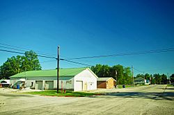
Washington Street in Claremont, July 2020
|
|

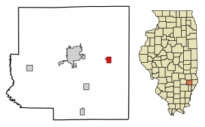
Location of Claremont in Richland County, Illinois.
|
|

Location of Illinois in the United States
|
|
| Country | United States |
| State | Illinois |
| County | Richland |
| Area | |
| • Total | 0.79 sq mi (2.05 km2) |
| • Land | 0.79 sq mi (2.05 km2) |
| • Water | 0.00 sq mi (0.00 km2) |
| Elevation | 509 ft (155 m) |
| Population
(2020)
|
|
| • Total | 161 |
| • Density | 203.03/sq mi (78.36/km2) |
| Time zone | UTC-6 (CST) |
| • Summer (DST) | UTC-5 (CDT) |
| ZIP Code(s) |
62421
|
| Area code(s) | 618 |
| FIPS code | 17–14533 |
| GNIS feature ID | 2397628 |
| Wikimedia Commons | Claremont, Illinois |
Claremont is a small village located in Richland County, Illinois, in the United States. In 2020, about 161 people lived there.
Contents
History of Claremont
Even though the village of Claremont was officially started in 1853, people first began settling in the wider Claremont area in 1818. This was the same year that Illinois became a state in the United States. In December 1852, the Claremont area was officially recognized as a "precinct."
Some of the very first settlers in the Claremont area included Lot Basden, who helped plan the nearby town of Olney. James Elliott owned land here, and Thomas L. Stewart was an early police officer and sheriff for Richland County. Martin Utterback is said to have helped move logs to build the first courthouse in the county. Other early families included the Laws, Blanchards, Bullards, Brinkleys, Coanours, and Calhouns.
Claremont village was designed by Jacob May. In 1853, he moved his store to a spot along an old road called the Trace Road. Two years later, in 1855, the O & M Railroad was built. Jacob May then moved his store again, this time next to the new railroad. This new location became the official site of the village of Claremont we know today.
Where is Claremont?
Claremont is located in southeastern Illinois. It is just southeast of a larger town called Olney. It is also just south of U.S. Route 150, which is a major road.
According to information from 2010, Claremont covers a total area of about 1.14 square miles (2.95 square kilometers). All of this area is land, meaning there are no large lakes or rivers within the village limits.
People of Claremont
| Historical population | |||
|---|---|---|---|
| Census | Pop. | %± | |
| 1860 | 121 | — | |
| 1870 | 120 | −0.8% | |
| 1880 | 163 | 35.8% | |
| 1890 | 212 | 30.1% | |
| 1900 | 226 | 6.6% | |
| 1910 | 186 | −17.7% | |
| 1920 | 186 | 0.0% | |
| 1930 | 179 | −3.8% | |
| 1940 | 205 | 14.5% | |
| 1950 | 249 | 21.5% | |
| 1960 | 223 | −10.4% | |
| 1970 | 269 | 20.6% | |
| 1980 | 255 | −5.2% | |
| 1990 | 256 | 0.4% | |
| 2000 | 212 | −17.2% | |
| 2010 | 176 | −17.0% | |
| 2020 | 161 | −8.5% | |
| U.S. Decennial Census | |||
The table to the left shows how the population of Claremont has changed over many years.
In the year 2000, there were 212 people living in the village. There were 91 households, which are groups of people living together in one home. The village had about 187 people per square mile (72 people per square kilometer). All of the people living in Claremont at that time were identified as White.
The average age of people in the village in 2000 was 39 years old. About 23.6% of the population was under 18 years old. About 17.5% of the people were 65 years old or older.
Famous People from Claremont
- James R. Lindsay was a brigadier general in the U.S. Army.
- Dial D. Ryder was a skilled gunsmith who was born in Claremont.
See also
 In Spanish: Claremont (Illinois) para niños


