Troublesome Creek (North Fork Kentucky River tributary) facts for kids
Troublesome Creek is a stream in Breathitt, Perry, and Knott counties, Kentucky. It is a branch, or "fork," of the North Fork Kentucky River.
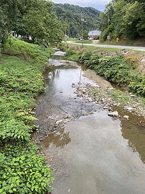
This creek is about 41.5 miles (66.8 kilometers) long. It flows freely most of the time. Its banks are sometimes lined with trees and sometimes open.
The creek starts where its Left and Right Forks meet in Hindman, which is the main town in Knott County. Troublesome Creek then flows into the North Fork of the Kentucky River near Haddix in Breathitt County.
Contents
Understanding Troublesome Creek's Branches
Troublesome Creek has many smaller streams that flow into it. These smaller streams are called tributaries. They add water to the main creek as it flows along.
- Some of its important tributaries include:
- Lost Creek
- Hayes Branch
- Halfway Branch
- Riley Branch
- Barge Creek
- Lewis Branch
- Russell Branch
- Millers Branch
- Caney Creek
- Fugate Fork
- Buckhorn Creek
- Balls Fork
- Clear Creek
- Montgomery Creek
- Mill Creek
- Big Branch
- Ogden Branch
- Cy Everidge Branch
The town of Hindman is located where the Left and Right Forks of Troublesome Creek come together. This area was once known as The Forks of Troublesome.
Troublesome Creek in Perry County
About 18 miles (29 kilometers) of Troublesome Creek flow through Perry County. Over the years, ten different post offices have been located along the creek in this county.
Early Post Offices and Mining History
The Troublesome post office opened in 1882. It was named after the creek itself. It moved a few times before closing in 1914.
Another post office, called Tub, opened in 1923. Its original name was meant to be "Troy," but that was not allowed. It closed in 1933.
Many coal mines used to operate along Troublesome Creek and its branches in Perry County. For example, Mowbray and Robinson had a mine in Upper Beaver Dam Branch. Floyd Campbell had a mine in Cat Hollow. These mines were important for the local economy.
Dwarf: A Post Office with a Special Name
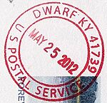
The Dwarf post office is one of the oldest in the area. It first opened in 1878 as Tunell Hill. It was named after a tunnel built by the Combs family for their mill.
In 1883, it reopened as Dwarf. This name came from Jeremiah Combs, a local settler who was known as "Short Jerry" because he was not very tall. The Dwarf post office is still open today.
Ary Post Office
The Ary post office started in 1906. It was originally meant to be named "Dory." The reason for the name "Ary" is not fully known. This post office moved several times and is still open today.
Rowdy and Stacy Post Offices
The Stacy post office opened in 1890. It was originally intended to be named "Noble" because it was near Noble Branch, but another post office already had that name.
The Rowdy post office also opened in 1890, named after the Rowdy Branch. Local stories say the branch was named because the people living there were "rowdy." This post office closed quickly in the same year. However, the Stacy post office later reopened in 1944 using the name "Rowdy," and it was still open in 2000.
Troublesome Creek in Breathitt County
Hardshell and Other Locations
The Hardshell post office opened in 1917. It was named after a local church called the Hardshell Baptists. This post office moved to different spots over the years and finally closed in 1994.
Many mines were also found in Breathitt County. For example, Elisha Miller had a coal mine on the Right Fork of Russell Branch. John E. Miller had a mine at Miller's Branch. These mines show how important coal was to the region.
A special measuring station for the North Fork Kentucky River is located near Noble. It helps scientists track the water levels and flow of the river.
Clayhole Post Office
The Clayhole post office started in 1899. It was reportedly named for the "sticky blue clay" found in the creek bed. It moved several times before settling in its current location at the mouth of Riley Branch.
Haddix Town and Post Office
The town of Haddix was founded when the railroad arrived at the mouth of Troublesome Creek. Both the town and its post office, which opened in 1916, were named after the Haddix family. This family were early settlers and landowners in the area. The Haddix post office closed in 1990.
Troublesome Creek in Knott County
Early Post Offices and Mining
The Mink post office opened in 1898 but closed after only a year. Its founder wanted to name it "Boggs," but that name was not allowed.
Many coal mines were also active in Knott County. For example, the Engle family had a mine on a small branch of Trace Branch. The Gearheart family also had mines in the area. These mines were a big part of the local economy.
Hindman: The County Seat
The city of Hindman is the main town in Knott County. It is located exactly where Troublesome Creek splits into its Left and Right forks. This area was originally known as The Forks of Troublesome.
Emmalena Post Office
The Emmalena post office opened in 1894. It is located about 8.5 miles (13.7 kilometers) west of Hindman. The name "Emmalena" is a mix of two names: "Emma" Thurman and "Orlena" Morgan, who was the first postmaster. The Morgan family has run this post office ever since it opened.
Fisty Post Office
The Fisty post office opened in 1906. It was named after "Fisty Sam" Combs, a member of a large local family. It is located at the mouth of Clear Creek and is still open today.
Carrie Post Office
The Carrie post office opened in 1912. It was named by its first postmaster, Henry Combs, after his wife, Carrie. It is located between Hindman and Emmalena and is still open.
Ritchie Family and Post Offices
The Ritchie post office opened in 1900, named after the local Ritchie family. Members of this family operated the post office until it closed in 1974. Many Ritchie family members also had coal mines in the area.
Everidge Family and Post Offices
The Tina post office opened in 1905, named for Clementina, the wife of a state senator. It moved many times along Montgomery Creek. After closing in 1914, it reopened in 1920 with Elvira Everage as postmaster. Several members of the Everage family ran the post office until it closed in 1978.
Understanding Flooding in Troublesome Creek
The entire Kentucky River Basin, including Troublesome Creek, often experiences floods. This happens because of heavy rainfall. The banks of the creeks are usually steep, so when floods occur, they mostly damage buildings, towns, and roads built near the creeks.
The ground in this area is often rocky. This means rainwater runs off into many small, temporary creeks instead of soaking into the soil. Because many towns are built along the creek beds, floods mainly damage buildings rather than farms.
Even though old mines might have made flooding worse by compacting the soil, they also flattened some areas. This can help reduce how much water flows directly into the small creeks.
Troublesome Creek had a major flood in January and February 1957. However, the biggest flood on record for the creek was in February 1939.
Another very large flood happened on July 28, 2022, after three days of heavy rain. This flood caused property damage in many places along the creek, including at Fisty, Carrie, and Lost Creek post offices. The city of Hindman was completely underwater.
In 1958, people thought about building a reservoir on Troublesome Creek to hold floodwaters, but the idea was rejected because it would not be big enough.
Projects are now working to plant more trees in old mine areas. These trees help by absorbing water with their leaves and roots, which can reduce the effects of heavy rainfall. Old mines also had special basins and ditches to catch rainwater, but these are not large enough for major floods.
Dredging, or digging out the creek bed, is not allowed because it could harm endangered fish like the local arrow fish. Also, the natural systems of the creek are often more effective, and there isn't much room to dredge because of the bedrock close to the surface.
Changes in land use, like building roads, cutting down trees, and farming, can increase the amount of sediment in the creek. This raises the creek beds and can cause more water to flow into the surrounding flood plains during floods.
Things Named After Troublesome Creek
The name "Troublesome Creek" itself is said to have been given by an early settler, Colby Haddix. It likely got its name because it was "troublesome" to travel along due to its many bends.
Several other things have also been named after the creek:
- James Still's book On Troublesome Creek is a collection of short stories.
- The "Blue Fugates" were a family nicknamed the "Blue People of Troublesome Creek." They lived in the area in the 1800s and 1900s. Some family members had blue-tinted skin due to a rare genetic condition called methemoglobinemia.
- The Troublesome Creek Times is a weekly newspaper for Knott County. It is published in Hindman.


