Cockpit Country facts for kids
Quick facts for kids
Cockpit Country
|
|
|---|---|
|
Geographical Region
|
|
 |
|
| Country | Jamaica |
| Parish | Trelawny |
| Named for | Topology reminiscent of the shape of cock fighting dens. |
| Time zone | UTC-5 (EST) |
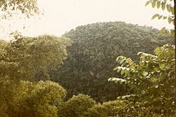
The Cockpit Country is a special area in Jamaica. It spans across several parishes like Trelawny, Saint Elizabeth, and Saint James. This unique place is known for its steep, hollow valleys, which can be as deep as 120 meters (about 390 feet). These valleys are separated by cone-shaped hills and ridges.
For a long time, the Cockpit Country has been a safe haven. Maroons, who were people who escaped from slavery, used this difficult landscape to their advantage. They built communities here, staying free from the control of Spanish or British colonists.
Contents
A Place of Freedom: History of Cockpit Country
In the late 1600s, the Cockpit Country became a refuge for Jamaican Maroons who were fleeing slavery. During the First Maroon War, there were two main Maroon communities in this area: Cudjoe's Town (Trelawny Town) and Accompong Town. Cudjoe's Town was in the mountains of Saint James Parish. Accompong is located nearby, on the border of Westmoreland and Saint Elizabeth.
In 1740, the Maroons signed a peace treaty with the colonial government. After this, they sometimes helped the authorities find runaway slaves hiding in the Cockpit Country. However, during the Second Maroon War, many runaway slaves joined forces with Trelawny Town.
After the Trelawny Maroons were sent away in 1796, it became harder for the Accompong Maroons to patrol the Cockpit Country. This allowed several new communities of runaway slaves to form there.
In the early 1800s, a leader named Cuffee started a community of runaway slaves in the Cockpit Country. They successfully fought against attempts by the colonial authorities and the Accompong Maroons to remove them. Later, another group of runaways from Trelawny Parish created a community called Me-no-Sen-You-no-Come. They also managed to stay free. During the Baptist War of 1831–32, even more enslaved people escaped and found freedom in this region.
Today, Accompong Town is still an active Maroon community. It has a special recognized independence under the Jamaican government.
Exploring the Unique Landscape
The northern edge of the Cockpit Country is marked by a long ridge called the "Escarpment." This ridge stretches from Flagstaff in the west to Campbells in the east. The Barbecue Bottom Road is the only road that crosses the Cockpit Country. It runs north to south along a deep valley.
For those who like to walk or ride, there are two old trails further west: the Troy Trail and the Quick Step Trail. These trails are not used much today and can be hard to find.
In the southwest, near Quick Step, there's an area known as the "Land of Look Behind." This name comes from a story about Spanish horsemen. When they rode into this area, which was home to hostile escaped slaves, they would ride two people on one horse. One rider would face backward to watch for ambushes.
Where the ridges between the sinkholes have worn away, flat-bottomed valleys have formed. These valleys are filled with rich red soil, called terra rossa. This soil is some of the most fertile on the island. The largest of these valleys is the Vale of Clarendon, which is 80 kilometers (50 miles) long and 32 kilometers (20 miles) wide. Other valleys like Queen of Spains Valley, Nassau Valley, and Cave Valley formed in a similar way.
Small, shallow caves, known locally as cockpits, are very common around the village of Quick Step. You can find as many as 15 caves per square kilometer there! Some famous caves include Marta Tick Cave and Minocal's Glory Hole. There are ideas to develop ecotourism in Quick Step, allowing visitors to explore the heart of Cockpit Country.
Amazing Animals and Plants
The Cockpit Country is home to Jamaica's largest remaining rainforest. This makes it a very important place for nature. In 1979, people suggested making the area a National Park to protect it. In 1994, a geographer named Alan Eyre proposed that the Cockpit Country should become a World Heritage Site. This would help preserve its unique environment for future generations. In 2006, a petition was sent to Prime Minister Bruce Golding asking for the area's protection.
Scientists from the University of the West Indies (UWI) have studied the area. They have proposed a boundary for the protected zone, and public discussions about this began in 2013.
The Cockpit Country is home to some very rare animals. For example, the Eleutherodactylus sisyphodemus is a tiny, critically endangered frog species found only here. Also, 90% of the world's population of the black-billed amazon, a parrot unique to Jamaica, lives in the Cockpit Country.
This region is also one of the last places where you can find the Jamaican swallowtail. This is the largest butterfly in the entire Western Hemisphere!
Protecting This Special Place
The Forest Reserve
The Cockpit Country Forest Reserve was created in 1950. It covers a large area of 221.75 square kilometers (about 85.6 square miles). This reserve helps protect the forests and wildlife within its boundaries.
See also
- Geography of Jamaica
 | Jessica Watkins |
 | Robert Henry Lawrence Jr. |
 | Mae Jemison |
 | Sian Proctor |
 | Guion Bluford |


