Colebee, New South Wales facts for kids
This page is about the suburb of Sydney. For the department store, see Schofields (department store).
Quick facts for kids ColebeeSydney, New South Wales |
|||||||||||||||
|---|---|---|---|---|---|---|---|---|---|---|---|---|---|---|---|

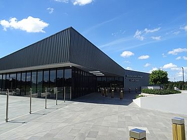
Stonecutters Ridge Golf Club
|
|||||||||||||||
| Population | 1,931 (2016 census) | ||||||||||||||
| Postcode(s) | 2761 | ||||||||||||||
| Elevation | 36 m (118 ft) | ||||||||||||||
| Location | 47 km (29 mi) west of Sydney CBD | ||||||||||||||
| LGA(s) | City of Blacktown | ||||||||||||||
| State electorate(s) | Mount Druitt Riverstone |
||||||||||||||
| Federal Division(s) | Chifley | ||||||||||||||
|
|||||||||||||||
Colebee is a suburb located in Sydney, New South Wales, Australia. It's about 47 kilometres west of the main city area, known as the Sydney CBD. Colebee is part of the City of Blacktown, which is a local government area in the Western Sydney region.
History of Colebee
Colebee gets its name from an important historical figure, Colebee. He was an Aboriginal man from the Boorooberongal clan. It's thought that he was the first Aboriginal person to be given land in the Blacktown area, specifically at Plumpton Ridge. Colebee was also the son of Yarramundi, another significant Aboriginal leader.
Important Places in Colebee
Colebee has some special places that are "heritage-listed." This means they are important historical sites that need to be protected. One of these sites is:
- Richmond Road: The Colebee and Nurragingy Land Grant
Black History Month on Kiddle
Outstanding African-American Women
 | Laphonza Butler |
 | Daisy Bates |
 | Elizabeth Piper Ensley |

All content from Kiddle encyclopedia articles (including the article images and facts) can be freely used under Attribution-ShareAlike license, unless stated otherwise. Cite this article:
Colebee, New South Wales Facts for Kids. Kiddle Encyclopedia.

