Collings Lakes, New Jersey facts for kids
Quick facts for kids
Collings Lakes, New Jersey
|
|
|---|---|

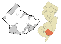
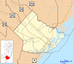
Map of Collings Lakes CDP in Atlantic County. Inset: Location of Atlantic County in New Jersey.
|
|
| Country | |
| State | |
| County | Atlantic |
| Township | Buena Vista |
| Area | |
| • Total | 0.70 sq mi (1.82 km2) |
| • Land | 0.64 sq mi (1.66 km2) |
| • Water | 0.06 sq mi (0.16 km2) 8.88% |
| Elevation | 79 ft (24 m) |
| Population
(2020)
|
|
| • Total | 1,501 |
| • Density | 2,338.01/sq mi (903.29/km2) |
| Time zone | UTC−05:00 (Eastern (EST)) |
| • Summer (DST) | UTC−04:00 (EDT) |
| ZIP Code |
08094
|
| Area code(s) | 609 |
| FIPS code | 34-14230 |
| GNIS feature ID | 02389344 |
Collings Lakes is a community in New Jersey. It is not a city or town with its own government. Instead, it is part of Buena Vista Township. Places like Collings Lakes are called "census-designated places" (CDP). This means the government counts the people living there for official records. In 2020, about 1,501 people lived in Collings Lakes.
Contents
About Collings Lakes
Collings Lakes is an "unincorporated community." This means it does not have its own local government. It is managed by the larger Buena Vista Township.
Community Association
Even without its own government, Collings Lakes has a group called the Collings Lakes Civic Association. This group helps with the community. Homeowners in Collings Lakes are asked to pay a small yearly fee. This money helps take care of the lakes and beaches in the area. Being a member of the Civic Association is not required.
Geography of Collings Lakes
Collings Lakes is located in Atlantic County. It covers a total area of about 0.70 square miles (1.82 square kilometers). Most of this area is land, about 0.64 square miles (1.66 square kilometers). A smaller part is water, about 0.06 square miles (0.16 square kilometers). This water makes up almost 9% of the total area.
Population Facts
The number of people living in Collings Lakes has changed over the years. Here is a quick look at the population counts:
- 1990: 2,046 people
- 2000: 1,726 people
- 2010: 1,706 people
- 2020: 1,501 people
2010 Population Details
In 2010, the census counted 1,706 people living in Collings Lakes. There were 575 households, which are groups of people living together. About 442 of these were families.
Most people in Collings Lakes were White (86.23%). Other groups included Black or African American (5.98%), Native American (0.53%), and Asian (0.59%). About 11.31% of the people were of Hispanic or Latino background.
Many households (33.2%) had children under 18 years old. Most households (58.4%) were married couples. About 14.1% were single mothers with no husband present.
The average age of people in Collings Lakes in 2010 was 38.3 years. About 25.3% of the population was under 18. About 10.6% were 65 years or older.
See also
 In Spanish: Collings Lakes para niños


