Columbia Plateau Aquifer System facts for kids
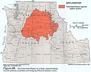
The Columbia Plateau Aquifer system is like a giant underground sponge that holds water. It's made of many layers of rock that can store water. This system stretches across a huge area, about 44,000 square miles, covering parts of Washington, Oregon, and Idaho. It's found within the Columbia Plateau region, surrounded by big mountain ranges like the Cascades and the Rocky Mountains. At the very bottom of these water-filled layers is a super thick layer of basalt rock, which can be as deep as 15,000 feet! Most of the water in this system is found in shallow layers, close to the surface.
How Clean is the Water?
Keeping the water clean in the Columbia Plateau Aquifer system is very important. One of the main worries about water quality comes from farming activities. This is especially true in the southwestern part of the system, where a lot of land is used for growing crops.
A study by the USGS in 2010 looked closely at the water quality. They found that a chemical called nitrates was a concern. Nitrates can come from fertilizers used on farms. In 17% of the wells they tested, the amount of nitrates was higher than the safe limit for drinking water.
Another thing they looked for was pesticides, like atrazine. Pesticides are chemicals used to protect crops from bugs and weeds. While pesticides were often found in the water, the good news is that they were usually at levels considered safe for people to drink.
How Much Water is There?
The water from the Columbia Plateau Aquifer system is mostly used for watering crops on farms. This is called irrigation. In some areas, farmers use a lot of surface irrigation, meaning they spread water over their fields. When they do this, some of the extra water soaks back into the ground. This helps to refill the aquifer, so there's less worry about running out of water in those places.
However, in other areas, like Umatilla and the Palouse slope, people are more concerned about the water levels dropping. This is called groundwater depletion. In the Umatilla area, for example, the water level has dropped quite a bit since the 1970s. It went from being 300 feet deep to only 100 feet deep in some spots.
Overall, between 1968 and 2009, the average water level in the aquifer system went down by about 1 foot each year. This shows why it's important to manage this underground water supply carefully.


