Como Dam facts for kids
Quick facts for kids Lake Como |
|
|---|---|

Como Dam and Reservoir
|
|
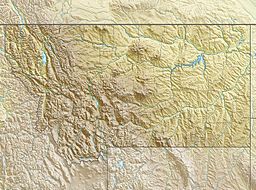
| Location | Ravalli County, Montana, United States |
| Coordinates | 46°03′16″N 114°15′40″W / 46.0545°N 114.261°W |
| Type | Reservoir |
| Primary inflows | Rock Creek, Little Rock Creek |
| Primary outflows | Rock Creek |
| Catchment area | 56.4 square miles (146 km2) |
| Max. length | 3 miles (4.8 km) |
| Max. width | 3,200 feet (980 m) |
| Water volume | 38,500 acre-feet (47,500,000 m3) |
| Surface elevation | 4,252 feet (1,296 m) |
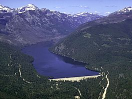
Lake Como and Como Dam are important landmarks in Ravalli County, Montana, in the western part of the United States. Lake Como is a beautiful reservoir, which is a lake created by a dam. The Como Dam helps to hold back water for many uses, especially for watering farms in the area. It's a popular spot for outdoor activities like fishing and camping, surrounded by the Bitterroot National Forest.
Contents
What is Como Dam?
Como Dam (official ID # MT00564) is a structure built across a river. It's located in Ravalli County, Montana. Dams like Como Dam are built to control water flow and create reservoirs.
Building the Dam
Farmers in the local area first built Como Dam around 1910. They needed a way to store water from a natural lake to help water their crops. Later, a government agency called the United States Bureau of Reclamation helped make the dam stronger and safer. They worked on it in 1954, 1976, and again in 1992-1993.
The dam is about 85 feet tall, which is like an eight-story building. It stretches for 2,550 feet across, which is almost half a mile! The dam and the lake it creates are owned by a local group called the Bitter Root Project Irrigation District. This group helps manage the water for farming.
Lake Como: The Reservoir
The lake created by Como Dam is called Lake Como. It covers about 1.4 square miles of water. It can hold a lot of water, about 38,495 acre-feet. An acre-foot is the amount of water needed to cover one acre of land with one foot of water. That's a huge amount of water!
Fun at Lake Como
Lake Como is a great place for outdoor fun. People enjoy:
- Fishing
- Camping
- Boating
The area around the lake is part of the Bitterroot National Forest. This means there are lots of trees and nature to explore.
Keeping the Dam Safe
In 2017, officials looked at ways to make sure Como Dam was very safe. They wanted to prevent any problems, especially if there was a lot of water at night. They took steps to ensure the dam could handle any situation and keep everyone in the Bitterroot Valley safe.
 | Sharif Bey |
 | Hale Woodruff |
 | Richmond Barthé |
 | Purvis Young |


