Ravalli County, Montana facts for kids
Quick facts for kids
Ravalli County
|
|
|---|---|

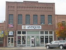
Independent Order of Odd Fellows Hall in Stevensville, Montana.
|
|

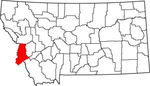
Location within the U.S. state of Montana
|
|
 Montana's location within the U.S. |
|
| Country | |
| State | |
| Founded | March 3, 1893 |
| Named for | Antonio Ravalli |
| Seat | Hamilton |
| Largest city | Hamilton |
| Area | |
| • Total | 2,400 sq mi (6,000 km2) |
| • Land | 2,391 sq mi (6,190 km2) |
| • Water | 9.4 sq mi (24 km2) 0.4% |
| Population
(2020)
|
|
| • Total | 44,174 |
| • Estimate
(2022)
|
47,298 |
| • Density | 18.4/sq mi (7.11/km2) |
| Time zone | UTC−7 (Mountain) |
| • Summer (DST) | UTC−6 (MDT) |
| Congressional district | 1st |
|
|
Ravalli County is a special area, called a county, located in the southwestern part of Montana, a state in the United States. In 2020, about 44,174 people lived there. The main town and center of the county is Hamilton.
Ravalli County is in a long valley between two mountain ranges. The Sapphire Mountains are on the east side, and the Bitterroot Mountains are on the west. People often call this area the Bitterroot Valley, named after the beautiful Bitterroot Flower. The county is also on the Pacific Ocean side of the Continental Divide. This is a line of high ground where rivers flow either to the Pacific Ocean or the Atlantic Ocean.
Contents
What is the History of Ravalli County?
Early People and Missions
Long ago, Ravalli County was the home of the Bitterroot Salish Native American tribe. The first Europeans to meet them were the Lewis and Clark Expedition in 1805. They wrote that the tribe was very friendly.
The Catholic Church wanted to set up a mission in the area. So, in 1841, they started St. Mary's Mission. This mission was later called Fort Owen. In 1864, the settlement got its current name, Stevensville. By 1891, the Salish tribe moved to the Flathead Reservation. This move happened because of an agreement called the Treaty of Hellgate.
Chief Joseph's Journey
In 1877, a famous leader named Chief Joseph and his group of Nez Perce people traveled through Ravalli County. They were trying to avoid being forced onto a reservation. They hoped to reach Canada for safety. However, they were captured before they could make it, just south of Havre.
How Ravalli County Was Formed
Ravalli County was officially created in 1893 by the Montana government. It was formed from a part of Missoula County. The county was named after Antony Ravalli, an Italian Jesuit priest. He came to the Bitterroot Valley in 1845.
What is the Geography of Ravalli County?
Ravalli County covers about 2,400 square miles. Most of this area, about 2,391 square miles, is land. The remaining 9.4 square miles, or 0.4%, is water.
Main Roads in Ravalli County
Neighboring Counties
Ravalli County shares borders with several other counties:
- Missoula County to the north
- Granite County to the northeast
- Deer Lodge County to the east
- Beaverhead County to the southeast
- Lemhi County, Idaho to the south
- Idaho County, Idaho to the west (this border is also where the time zone changes to Pacific Time)
Protected Natural Areas
Part of Ravalli County includes areas that are protected for nature and wildlife:
- Bitterroot National Forest (a part of it)
- Lee Metcalf National Wildlife Refuge
- Lolo National Forest (a part of it)
What is the Population of Ravalli County?
| Historical population | |||
|---|---|---|---|
| Census | Pop. | %± | |
| 1900 | 7,822 | — | |
| 1910 | 11,666 | 49.1% | |
| 1920 | 10,098 | −13.4% | |
| 1930 | 10,315 | 2.1% | |
| 1940 | 12,478 | 21.0% | |
| 1950 | 13,101 | 5.0% | |
| 1960 | 12,341 | −5.8% | |
| 1970 | 14,409 | 16.8% | |
| 1980 | 22,493 | 56.1% | |
| 1990 | 25,010 | 11.2% | |
| 2000 | 36,070 | 44.2% | |
| 2010 | 40,212 | 11.5% | |
| 2020 | 44,174 | 9.9% | |
| 2022 (est.) | 47,298 | 17.6% | |
| U.S. Decennial Census 1790–1960, 1900–1990, 1990–2000, 2010–2020 |
|||
Population in 2020
According to the 2020 census, there were 44,174 people living in Ravalli County.
Population in 2010
In the 2010 census, the county had 40,212 people. There were 16,933 homes and 11,380 families. About 16.8 people lived in each square mile. Most people (95.9%) were white. Other groups included American Indian, Asian, and Black or African American. About 3.0% of the people were of Hispanic or Latino background.
Many people in Ravalli County had ancestors from Germany (28.8%), England (17.4%), or Ireland (15.9%). The average age of people in the county was 46 years old.
What is the Economy of Ravalli County Like?
The main ways people make a living in Ravalli County are through farming and timber (cutting down trees for wood). Marcus Daly, a very rich person known for copper mining in Butte, helped fund logging in the Bitterroot Valley. This wood was important for his copper mining business.
More recently, tourism has become a bigger part of the economy. The valley is next to the Selway-Bitterroot Wilderness, a large wild area. This area has many different kinds of animals, including some of the last wolverine and wolf populations in the United States. There is also a place to ski called Lost Trail Powder Mountain at Lost Trail Pass, right on the Idaho border.
What are the Communities in Ravalli County?
Cities
Towns
Census-Designated Places
These are areas that are like towns but are not officially incorporated as cities or towns.
Unincorporated Communities
These are smaller communities that are not officially part of a city or town.
- Alta
- Bell Crossing
- Cinnibar Court
- Como
- Gorus
- Grantsdale
- Medicine Hot Springs
- Riverside
Who is a Notable Person from Ravalli County?
- Henry L. Myers was a lawyer for Ravalli County. He later became a U.S. Senator for Montana.
See also
 In Spanish: Condado de Ravalli para niños
 | Charles R. Drew |
 | Benjamin Banneker |
 | Jane C. Wright |
 | Roger Arliner Young |

