Cornell, Illinois facts for kids
Quick facts for kids
Cornell, Illinois
|
|
|---|---|

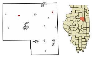
Location in Livingston County, Illinois
|
|

Location of Illinois in the United States
|
|
| Country | United States |
| State | Illinois |
| County | Livingston |
| Township | Amity |
| Area | |
| • Total | 0.65 sq mi (1.69 km2) |
| • Land | 0.65 sq mi (1.69 km2) |
| Elevation | 633 ft (193 m) |
| Population
(2020)
|
|
| • Total | 446 |
| • Density | 681.96/sq mi (263.20/km2) |
| Time zone | UTC-6 (CST) |
| • Summer (DST) | UTC-5 (CDT) |
| ZIP code |
61319
|
| Area codes | 815 & 779 |
| FIPS code | 17-16405 |
| GNIS feature ID | 2398628 |
| Wikimedia Commons | Cornell, Illinois |
Cornell is a small village located in Livingston County, Illinois, in the United States. In 2020, about 446 people lived there.
History of Cornell
The modern village of Cornell actually started as two separate towns. Both towns were created around the same time. They hoped to attract a train station for the new Fairbury Pontiac and Northwestern Railroad. This railroad later became part of the Wabash Railroad.
The town of Cornell was first planned by Walter P. Cornell on June 15, 1871. Just two days later, Willard D. Blake planned the nearby town of Amity. Walter Cornell was born in Rhode Island. He moved to Illinois in 1837 and helped with the railroad. Willard Blake was a farmer from LaSalle County, Illinois.
Even though the name Cornell was chosen for the new village, many of the first businesses were in the Amity part of the area. Some early houses built in Cornell were even moved to Amity. Cornell officially became an organized town in 1873.
The original town of Cornell was built around a public area. Today, this area is called North Park. Years ago, Cornell had many businesses. These included grocery stores, a bank, and four churches. There was also a stockyard, a harness shop, and a local newspaper called the Cornell Journal.
Geography of Cornell
Cornell is located in the northwestern part of Livingston County. This is in the northeastern section of Amity Township.
Illinois Route 23 is a main road that goes through the village. This road leads northwest about 14 miles (23 km) to Streator. It also goes southeast about 12 miles (19 km) to Pontiac. Pontiac is the main town, or county seat, of Livingston County.
According to information from 2010, Cornell covers a total area of about 0.64 square miles (1.66 square kilometers). All of this area is land.
Population of Cornell
The population of Cornell has changed over the years. Here's how many people have lived in the village during different census years:
| Historical population | |||
|---|---|---|---|
| Census | Pop. | %± | |
| 1880 | 437 | — | |
| 1890 | 437 | 0.0% | |
| 1900 | 521 | 19.2% | |
| 1910 | 536 | 2.9% | |
| 1920 | 528 | −1.5% | |
| 1930 | 455 | −13.8% | |
| 1940 | 478 | 5.1% | |
| 1950 | 458 | −4.2% | |
| 1960 | 524 | 14.4% | |
| 1970 | 532 | 1.5% | |
| 1980 | 603 | 13.3% | |
| 1990 | 556 | −7.8% | |
| 2000 | 511 | −8.1% | |
| 2010 | 467 | −8.6% | |
| 2020 | 446 | −4.5% | |
| U.S. Decennial Census | |||
In the year 2000, there were 511 people living in Cornell. There were 205 households, which are groups of people living together. About 142 of these were families. The average household had about 2.49 people. The average family had about 3.06 people.
The population included people of different ages. About 26.2% of the people were under 18 years old. About 13.1% were 65 years or older. The average age in the village was 39 years.
See also
 In Spanish: Cornell (Illinois) para niños

