kids encyclopedia robot

County of Elphinstone facts for kids

Kids Encyclopedia Facts
Quick facts for kids
Elphinstone
Queensland
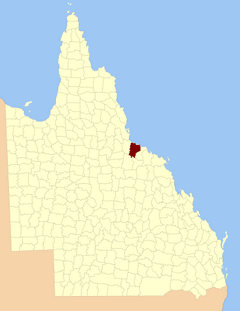
Elphinstone-county-queensland.png
Location within Queensland
Lands administrative divisions around Elphinstone:
Wilkie Gray Pacific Ocean Pacific Ocean
Wilkie Gray Elphinstone Gladstone
Davenport Davenport Murray

The County of Elphinstone is a cadastral division of Queensland which contains the city of Townsville. It was named after George Elphinstone Dalrymple (1826–1876), a politician and explorer. The county is divided into civil parishes.Townsville is mentioned as being in the county of Elphinstone in the 1911 Britannica. It is bounded by the Haughton River in the east, and part of the Burdekin River in the south-west.

Parishes

Elphinstone is divided into parishes, listed as follows:

Parish LGA Coordinates Towns
Abbotsford Burdekin 19°27′S 147°03′E / 19.450°S 147.050°E / -19.450; 147.050 (Abbotsford Parish) Cungulla
Beor Townsville 19°22′S 146°52′E / 19.367°S 146.867°E / -19.367; 146.867 (Beor Parish) Oonoonba
Bohle Townsville 19°15′S 146°40′E / 19.250°S 146.667°E / -19.250; 146.667 (Bohle Parish) Deeragun
Cardington Charters Towers 19°49′S 146°48′E / 19.817°S 146.800°E / -19.817; 146.800 (Cardington Parish)
Coonambelah Townsville 19°14′S 146°47′E / 19.233°S 146.783°E / -19.233; 146.783 (Coonambelah Parish) Townsville, Kirwan, Pallarenda
Crimea Charters Towers 19°45′S 146°40′E / 19.750°S 146.667°E / -19.750; 146.667 (Crimea Parish)
Cunningham Charters Towers 19°54′S 146°44′E / 19.900°S 146.733°E / -19.900; 146.733 (Cunningham Parish) Mingela
Ettrick Townsville 19°19′S 147°00′E / 19.317°S 147.000°E / -19.317; 147.000 (Ettrick Parish)
Glenrock Townsville 19°37′S 146°38′E / 19.617°S 146.633°E / -19.617; 146.633 (Glenrock Parish)
Granite Townsville 19°30′S 146°37′E / 19.500°S 146.617°E / -19.500; 146.617 (Granite Parish)
Halifax Townsville 19°13′S 146°33′E / 19.217°S 146.550°E / -19.217; 146.550 (Halifax Parish) Bluewater
Hervey Townsville 19°21′S 146°30′E / 19.350°S 146.500°E / -19.350; 146.500 (Hervey Parish)
Lansdowne Townsville 19°30′S 146°47′E / 19.500°S 146.783°E / -19.500; 146.783 (Lansdowne Parish)
Magenta Townsville 19°38′S 146°52′E / 19.633°S 146.867°E / -19.633; 146.867 (Magenta Parish) Woodstock
Magnetic Townsville 19°07′S 146°49′E / 19.117°S 146.817°E / -19.117; 146.817 (Magnetic Parish) Magnetic Island
Rokeby Townsville 19°32′S 146°56′E / 19.533°S 146.933°E / -19.533; 146.933 (Rokeby Parish)
Ross Townsville 19°23′S 146°40′E / 19.383°S 146.667°E / -19.383; 146.667 (Ross Parish) Alice River, Kelso
Scott Burdekin 19°34′S 147°03′E / 19.567°S 147.050°E / -19.567; 147.050 (Scott Parish) Giru
Stuart Townsville 19°22′S 146°48′E / 19.367°S 146.800°E / -19.367; 146.800 (Stuart Parish) Stuart, Annandale, Douglas
Woodstock Townsville 19°42′S 146°59′E / 19.700°S 146.983°E / -19.700; 146.983 (Woodstock Parish)
Wyoming Townsville 19°38′S 146°47′E / 19.633°S 146.783°E / -19.633; 146.783 (Wyoming Parish)
kids search engine
County of Elphinstone Facts for Kids. Kiddle Encyclopedia.