Cramond Island facts for kids
| Gaelic name | Eilean Chathair Amain |
|---|---|
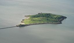 Cramond Island from the air |
|
| Coordinates | 55°59′35″N 3°17′23″W / 55.9930°N 3.2898°W |
| Physical geography | |
| Island group | Islands of the Forth |
| Area | 7.70 ha |
| Administration | |
| Sovereign state | United Kingdom |
| Country | Scotland |
Cramond Island (in Scottish Gaelic Eilean Chathair Amain) is a small island in the Firth of Forth. This is a large bay on the east coast of Scotland, near Edinburgh. The island is located just off the shore at Cramond. It is about 536 meters (1/3 of a mile) long and covers 7.7 hectares (19 acres). The island is part of the Dalmeny Estate. It is currently used by the Cramond Boat Club.
Contents
Exploring Cramond Island
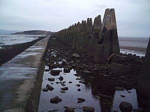
Cramond Island is a special type of island called a tidal island. This means you can walk to it from the mainland when the tide is low. It's about 1.6 kilometers (1 mile) from the shore. A paved path, called a causeway, appears when the water is low. This path makes it easy to walk across.
The Causeway and Pylons
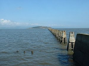
Along one side of the causeway, you'll see a row of concrete pillars, or pylons. These were built during the Second World War. They were part of an "anti-boat boom" to stop enemy boats. These pylons are a famous sight in the area.
Staying Safe from the Tide
When the tide comes in, the path gets covered by several feet of seawater. This cuts off the island from the mainland. It's safe to walk to the island at low tide. But you must make sure you have enough time to return before the water rises. The tide can come in very quickly, trapping people on the island. A large sign at the start of the causeway warns visitors about this danger. If you ignore the warning, you could get stuck until the next low tide.
Coastguards suggest crossing only during the two hours before and after low tide. The RNLI (Royal National Lifeboat Institute) Queensferry website lists "safe crossing times." It tells you the best times to go to the island and when you need to be back on the mainland.
Location and Recreation
The island is located in the mouth of the River Almond. This river flows into the Firth of Forth. Cramond Island is a popular spot for people to visit and enjoy the outdoors. It is one of 43 tidal islands in Great Britain that you can walk to. It is also one of 17 such islands off the Scottish mainland.
Island History
People have lived near Cramond Island for a very long time. There's evidence that ancient people found the island important. An early Christian burial site, called a cist, was found there during World War II.
Roman Times
Near Cramond Island was a Roman fort. So, it's likely the Romans used the island too. The Romans were in Scotland for a while, and Cramond is a very important place for finding Roman artifacts.
Ancient Stronghold
Some historians believe Cramond Island might be the site of an old stronghold called Urbs Iudeu. This place was mentioned by a famous historian named Bede. In 655 AD, a king named Osweo of Northumbria was surrounded here by his enemies. He paid them off with treasures to make them leave. The island's old name, Iodeo, even gave its name to the Firth of Forth in ancient Welsh!
Later History
In 1596, King James VI allowed two men to fight a duel on Cramond Island. This was to settle an argument. One man, Adam Bruntfield, killed the other.
For much of its history, Cramond Island was used for farming, especially sheep. It might also have been a place for fishing. The island was once known for its oyster beds, but too much fishing destroyed them.
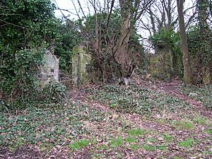
On the northwest side of the island, you can see the remains of a jetty (a small pier). It was built with local stone and might be from the medieval period. In the middle of the island, hidden by trees, are the ruins of an old stone farmstead. This farm was used until the 1930s, and sheep were still kept on the island in the 1960s.
World War I Defenses
In 1914, during the First World War, defenses were set up across the Firth of Forth. An anti-submarine net stretched from Cramond Island to other islands. Cramond Island had two guns to protect the area.
World War II Defenses
When World War II started, Cramond Island was made stronger with new defenses. It had two powerful guns and a modern gun designed to stop fast torpedo boats. An anti-submarine net and an anti-boat barrier were placed from Cramond Island to the Fife coast. This barrier protected ships and the Rosyth Dockyard. The line of concrete pylons you see today was part of this anti-boat barrier.
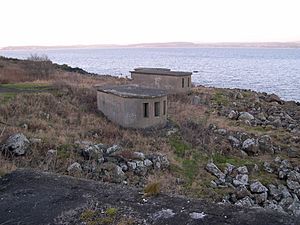
After crossing the causeway, you can see the places where a 75mm gun and its searchlight were located. Several buildings from World War II are still there. These include shelters, storage areas, and engine rooms that provided power for the military equipment. You can also see the anchor points for the anti-submarine net at the north end of the island when the tide is low.
Further along the northern coast, you might spot low concrete stumps. These are all that's left of the barracks where the soldiers lived. On the western side, there's a small brick building. Nearby, a ruined stone building was used to store ammunition during the war. Its old stone walls suggest it might be much older than the wars.
See also
 In Spanish: Cramond para niños
 | Selma Burke |
 | Pauline Powell Burns |
 | Frederick J. Brown |
 | Robert Blackburn |


