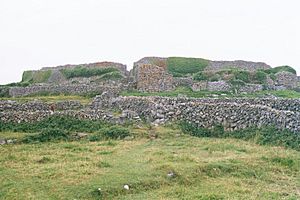
Dún Conor facts for kids
Quick facts for kids Dún Conor |
|
|---|---|
| Native name Irish: Dún Crocbhur · Dún Chonchuir · Dún Chonchubhair |
|
| Conor's Fort, Doonconor, The Black Fort | |
 |
|
| Type | stone ringfort |
| Location | Carrowntemple, Inishmaan, County Galway, Ireland |
| Area | 1,900 m2 (0.47 acres) |
| Elevation | 73 m (240 ft) |
| Height | 5 m (16 ft) |
| Architectural style(s) | Gaelic Ireland |
| Owner | State |
| Official name: Dun Conor Cashel | |
| Reference no. | 42 |
| Lua error in Module:Location_map at line 420: attempt to index field 'wikibase' (a nil value). | |
Dún Conor is an amazing ancient stone fort located on Inishmaan, one of the Aran Islands in Ireland. It's also known as "Conor's Fort" and is a special National Monument, meaning it's protected because of its historical importance. This fort is a great example of an old stone ringfort, which is a type of circular or oval fort built with stone walls.
Contents
Where is Dún Conor Located?
Dún Conor sits right in the middle of Inishmaan island. It's built on the highest point of the island, which would have given people a great view of everything around them in ancient times.
The Ancient Story of Dún Conor
How Old is Dún Conor?
Experts believe Dún Conor was built thousands of years ago, possibly between 1000 BC and 1 AD. Imagine how long ago that was! Back then, the sea levels were much lower. This means the Aran Islands, where Dún Conor is, were actually connected to the mainland of Ireland. Other forts, like Dún Aengus, were not right on the coast as they are today.
Why Dún Conor is Special
Many ancient forts have been damaged by time and the ocean. But Dún Conor's location in the center of the island helped protect it. It's still standing strong today!
Legends and Names
The name "Dún Conor" means "Conor's Fort." Legends say it was named after a man named Conor, who was the son of Hua Mór and brother of Aengus. The huge size of the forts on the Aran Islands also led to stories about the Fir Bolg, a mythical group of people in Irish folklore.
Restoring the Fort
In 1839, a famous scholar named John O'Donovan visited Dún Conor. Later, in the 1880s, some of the small stone huts inside the fort, called clocháns, were carefully restored. This helped preserve them for us to see today.
What Dún Conor Looks Like
Dún Conor is a stone fort shaped like an uneven oval. It measures about 69 meters (226 feet) from north to south and 35 meters (115 feet) from east to west. Even though it's smaller than Dún Aengus, its walls are much thicker. In some places, the walls are up to 6 meters (20 feet) thick!
Inside the Fort
The fort is built with four levels, or "terraces," and has stairs inside that connect them. The wall on the west side of the fort is built right on top of a natural cliff. This made it extra hard for enemies to attack from that direction. The other sides of the fort have a second wall for protection, and there's a strong tower-like part called a "bastion" in the northeast corner.
 | Percy Lavon Julian |
 | Katherine Johnson |
 | George Washington Carver |
 | Annie Easley |


