
Dandenong Ranges National Park facts for kids
Quick facts for kids Dandenong Ranges National ParkVictoria |
|
|---|---|
|
IUCN Category II (National Park)
|
|

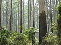
Ferntree Gully Forest on the Kokoda Track Memorial Walk
|
|

Dandenong Ranges National Park
Location in Victoria
|
|
| Nearest town or city | |
| Established | 13 December 1987 |
| Area | 35.4 km2 (13.7 sq mi) |
| Visitation | over 1,000,000 (in 2010) |
| Managing authorities | Parks Victoria |
| Website | Dandenong Ranges National Park |
| See also | Protected areas of Victoria |
The Dandenong Ranges National Park is a special place in Victoria, Australia. It is a national park found in the Greater Melbourne area. This park is about 31 kilometres (19 mi) to 45 kilometres (28 mi) east of the Melbourne City Centre.
The park covers a large area of about 3,540-hectare (8,700-acre). It was officially created on 13 December 1987. This happened by joining together a few smaller parks and areas. These included Ferntree Gully National Park, Sherbrooke Forest, and Doongalla Estate. Later, in 1997, more areas like Olinda State Forest were added.
Contents
History of the Park
Early Days and Timber
Long ago, the land where the Dandenong Ranges National Park now stands was home to the Bunurong and Woewurrong Aboriginal people. They lived here for thousands of years.
Later, the forests became very important for timber. Many trees were cut down to help build the city of Melbourne.
Farming and Tourism Begin
In the late 1800s, people started farming in the area. Roads and railways were built to connect the region. A famous narrow-gauge train line, called 'Puffing Billy', started running in 1900. It went from Ferntree Gully to Gembrook.
People also started visiting the Dandenong Ranges for fun. Tourism became popular from the 1870s.
Protecting the Land
Some areas were set aside as parks quite early. Fern Tree Gully was one of the first, becoming a park in 1882. Over time, more land was protected. Finally, the large Dandenong Ranges National Park was created in 1987. This helped to save these beautiful forests for everyone to enjoy.
Exploring the Park's Sections
The Dandenong Ranges National Park is divided into five main parts. Each section offers unique features and activities.
Doongalla Forest
This section includes Mount Dandenong itself. Here you can find the SkyHigh lookout. From this spot, you get amazing views of Melbourne's eastern suburbs. It's a great place to see the city from above.
Ferntree Gully Section
This part of the park is in the southwest. It is located near suburbs like Ferntree Gully and Boronia.
The 1000 Steps Trail
A very popular spot here is the Thousands Steps trail. This trail leads up to One Tree Hill. It's a steep walk with over 700 steps. The trail is about 2.5 kilometres (1.6 mi) long.
The 1000 Steps remember the soldiers who fought in the battle for the Kokoda track. This battle took place in Territory of Papua during World War II. Many people visit the steps for exercise and to enjoy nature. Even some Australian rules football teams use the steps for training!
The steps are believed to have been built in the early 1860s. Back then, they were the only way to reach the One Tree Hill Summit. The rest of the area was very thick forest. Today, many visitors come here for fitness walks and picnics.
Mount Evelyn Forest
This is the northernmost section of the park. It offers different walking trails and natural beauty.
Olinda Forest
You can find Olinda Forest on the eastern slopes of Mount Dandenong. It's another beautiful part of the park to explore.
Sherbrooke Forest
Sherbrooke Forest is well-known for its tall trees and peaceful atmosphere. It's a great place to spot native wildlife.
Protecting Native Animals
Because the park is close to a city, it sometimes has problems with animals that don't belong there. These are called feral animals. They can harm the native wildlife.
A few years ago, a rule was made for cats in the Dandenong Ranges area. This rule means cats must stay indoors at certain times. Since then, the number of native birds, like lyrebirds, has grown a lot. This shows how important it is to protect our local animals.
Images for kids
-
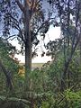
Sherbrooke Forest
-
1000 Steps, Kokoda Track Memorial Walk, Dandenong Ranges National Park
-
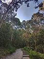
Lyrebird Track, Dandenong Ranges National Park


