Darbydale, Ohio facts for kids
Quick facts for kids
Darbydale, Ohio
|
|
|---|---|

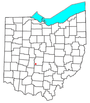
Location of Darbydale, Ohio
|
|
| Country | United States |
| State | Ohio |
| County | Franklin |
| Township | Pleasant |
| Area | |
| • Total | 1.01 sq mi (2.63 km2) |
| • Land | 1.00 sq mi (2.58 km2) |
| • Water | 0.02 sq mi (0.05 km2) |
| Elevation | 873 ft (266 m) |
| Population
(2020)
|
|
| • Total | 768 |
| • Density | 771.08/sq mi (297.75/km2) |
| Time zone | UTC-5 (Eastern (EST)) |
| • Summer (DST) | UTC-4 (EDT) |
| ZIP code |
43123
|
| FIPS code | 39-20198 |
| GNIS feature ID | 2628882 |
Darbydale is a small community in Franklin County, Ohio, United States. It's known as a census-designated place (CDP). A CDP is like a town that isn't officially a city or village, but the government still counts its population.
Darbydale used to be an official village. But on December 27, 1985, it stopped being an official village. In 2020, about 768 people lived there.
This community is located in the southwest part of Franklin County. It sits on the north side of Big Darby Creek. This creek flows into the Scioto River. Darbydale is about 14 miles southwest of downtown Columbus, Ohio.
Population Information
This section tells us about the number of people living in Darbydale over time.
| Historical population | |||
|---|---|---|---|
| Census | Pop. | %± | |
| 2010 | 793 | — | |
| 2020 | 768 | −3.2% | |
| U.S. Decennial Census | |||
- In 2010, the population was 793 people.
- By 2020, the population had slightly decreased to 768 people.
- In 2021, it was estimated that about 796 people lived in Darbydale.
See also
 In Spanish: Darbydale (Ohio) para niños

All content from Kiddle encyclopedia articles (including the article images and facts) can be freely used under Attribution-ShareAlike license, unless stated otherwise. Cite this article:
Darbydale, Ohio Facts for Kids. Kiddle Encyclopedia.
