Daw's Castle facts for kids
Quick facts for kids Daw's Castle |
|
|---|---|

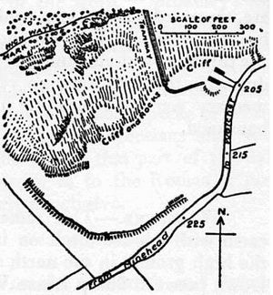
Plan of earthworks at Daw's Castle
|
|
| Location | Watchet, Somerset, England |
| Area | 2 hectares (4.9 acres) |
| Built | Iron Age |
| Reference no. | 188490 |
| Lua error in Module:Location_map at line 420: attempt to index field 'wikibase' (a nil value). | |
Daw's Castle, also known as Dart's Castle or Dane's Castle, is an ancient hill fort located on a sea cliff. It sits just west of Watchet, a harbour town in Somerset, England. This site is a special historical place called a Scheduled Ancient Monument, meaning it's protected by law.
The name "Daw's Castle" comes from Thomas Dawe, who owned a field called "castell" in 1537.
Contents
Daw's Castle: An Ancient Fort
Where is Daw's Castle Located?
The fort is built on a cliff that runs from east to west, about 80 meters (260 feet) above the sea. It's on a narrow piece of land, with the Washford River flowing to its south. This river goes into the sea near Watchet, about 1 kilometer (0.6 miles) to the east.
Originally, the fort's walls would have formed a half-circle, with the sheer cliffs behind them. However, the sea has slowly worn away parts of the cliff over time. Also, farming, old lime kilns, and the B3191 road have damaged the site. Today, only about 300 meters (980 feet) of the original walls can still be seen.
Built for Defense: From Iron Age to King Alfred
Daw's Castle might have first been built during the Iron Age, a time when people made tools and weapons from iron. Later, around 878 AD, it was rebuilt and strengthened by King Alfred. He turned it into a burh, which was a fortified town or stronghold.
King Alfred used these forts to defend against Viking raids coming from the Bristol Channel. Daw's Castle was part of a chain of forts and lookout posts along the coast. These forts were connected by a "military road" called the Herepath. This road allowed Alfred to move his army quickly to respond to Viking movements at sea.
Discoveries from Excavations
Archaeologists have dug at Daw's Castle and found evidence of two main building phases. The first defense phase had a wall made of stone and mortar in front of an earth bank. This was from the time of King Alfred's defense against the Vikings.
A second phase of defense was built in the late 9th or early 10th centuries. This was also to protect against more Viking invaders.
Watchet's Connection and Viking Raids
The Burghal Hidage is an old document from 919 that lists fortified places. It says that nearby Watchet had 513 "hides," which was a way to measure land for taxes. This number suggests a defensive wall about 645 meters (2,116 feet) long. It's not completely clear if this measurement was for the town walls of Watchet or for Daw's Castle high on the cliff.
The Anglo-Saxon Chronicle, an ancient record of English history, tells us about a Viking raid on Watchet in 914. The Vikings were defeated in a big battle, and only a few of them managed to escape back to their ships.
There were more Viking attacks later. In 987, there was a raid where they took many things. Another raid happened in 997, causing "much evil" with burning and killings.
A Saxon mint, where coins were made, was set up in Watchet in 1035. This mint was probably located inside Daw's Castle, rather than in the town below.
 | Jackie Robinson |
 | Jack Johnson |
 | Althea Gibson |
 | Arthur Ashe |
 | Muhammad Ali |

