Deggendorf (district) facts for kids
Quick facts for kids
Deggendorf
|
||
|---|---|---|
|
||
| Country | ||
| State | Bavaria | |
| Adm. region | Lower Bavaria | |
| Region | Donau-Wald | |
| Capital | Deggendorf | |
| Area | ||
| • Total | 861 km2 (332 sq mi) | |
| Population
(2000)
|
||
| • Total | 115,500 | |
| • Density | 134.15/km2 (347.4/sq mi) | |
| Time zone | UTC+1 (CET) | |
| • Summer (DST) | UTC+2 (CEST) | |
| Vehicle registration | DEG | |
| Website | landkreis-deggendorf.de | |
Deggendorf is a special area called a Landkreis, or district, in Bavaria, Germany. It's a place where many people live and work, and it has its own local government.
Geography of Deggendorf
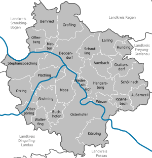
The beautiful Danube river flows right through the Deggendorf district. It travels from the west side to the east side. Another important river, the Isar, comes from the south. It joins the Danube close to the main town of Deggendorf.
The district also has some cool mountains! The highest point in the area is a mountain called Einödriegel. It stands tall at 1,220 meters (about 4,000 feet) high.
Towns and Villages
The Deggendorf district is home to several towns and many smaller villages. The biggest towns are Deggendorf, Osterhofen, and Plattling. These places are where many people live, shop, and go to school. The district also includes lots of smaller communities, each with its own unique charm.
See also
 In Spanish: Distrito de Deggendorf para niños
 | Emma Amos |
 | Edward Mitchell Bannister |
 | Larry D. Alexander |
 | Ernie Barnes |


