
Dennes Point, Tasmania facts for kids
Quick facts for kids Dennes PointTasmania |
|||||||||||||||
|---|---|---|---|---|---|---|---|---|---|---|---|---|---|---|---|
 |
|||||||||||||||

Dennes Point
Location in Tasmania
|
|||||||||||||||
| Population | 49 (2016 census) | ||||||||||||||
| Postcode(s) | 7150 | ||||||||||||||
| Location | 3 km (2 mi) NE of Killora | ||||||||||||||
| LGA(s) | Kingborough | ||||||||||||||
| Region | Hobart | ||||||||||||||
| State electorate(s) | Franklin | ||||||||||||||
| Federal Division(s) | Franklin | ||||||||||||||
|
|||||||||||||||
Dennes Point is a small, quiet place located at the very northern tip of Bruny Island in Tasmania, Australia. It's considered a semi-rural area, meaning it has a mix of country and residential features. In 2016, only 49 people lived there, making it a very small community. It's part of the Kingborough Council area, which is near the city of Hobart. The locality is about 3 kilometers (about 2 miles) north-east of the town of Killora.
Contents
A Look Back in Time: Dennes Point's History
How Dennes Point Got Its Name
Dennes Point officially became a recognized place in 1967. Before that, it was known by a different name: Kelly's Point. This earlier name came from a brave shipmaster and harbor pilot named James Kelly.
However, the area was later named after the Denne family. They were some of the first settlers here, arriving as farmers around the 1830s.
Ferry Services and Farming Life
In 1847, Anthony Smith Denne started a regular ferry service. This ferry traveled across the D'Entrecasteaux Channel between Tinderbox and what was then "Kelly's" Point. Today, you can still get to Bruny Island by a car ferry, but it travels between Kettering and Roberts Point.
Over the years, Dennes Point was a place for different kinds of farming. People grew fruit in orchards and raised animals through light grazing. The local post office opened in 1941 but closed its doors in 1984.
Geography of Dennes Point
The western edge of Dennes Point is bordered by the beautiful waters of the D’Entrecasteaux Channel. This channel separates Bruny Island from mainland Tasmania.
Getting Around: Roads in Dennes Point
Route C625 is the main road that goes through Dennes Point. It's known as Nebraska Road and also as Bruny Island Main Road. This road helps people travel from the southern parts of the area towards the east.
Images for kids
-
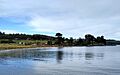
A view of Dennes Point
-
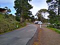
Nebraska Road in Dennes Point


