Devil's Thumb (Queensland) facts for kids
Quick facts for kids Devils Thumb |
|
|---|---|
| Manjal Jimalji | |
| Highest point | |
| Elevation | 1,065 m (3,494 ft) |
| Geography | |
| Location | Mossman, Queensland, Australia |
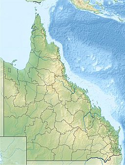
Devils Thumb, also known as Manjal Jimalji by the Eastern Kuku Yalanji people, is a tall and impressive mountain. You can find it near the town of Mossman in Far North Queensland, Australia. This amazing peak is part of the famous Daintree National Park.
Devils Thumb stands at a height of 1065 metres (about 3,494 feet) above sea level. That's taller than many famous skyscrapers! It's a special place for both its natural beauty and its cultural importance to the local Indigenous people.
Contents
Discovering Devils Thumb
Devils Thumb is a significant landmark in Far North Queensland. It's not just a big rock; it's a key part of the landscape. The mountain is known for its unique shape, which might remind some people of a thumb.
Where is Devils Thumb?
This mountain is located in a very special part of Australia. It's found near the town of Mossman, which is north of Cairns. Devils Thumb is right inside the Daintree National Park. This park is famous for having one of the oldest rainforests in the world. Imagine a forest that has been growing for millions of years!
The Daintree National Park is a UNESCO World Heritage Site. This means it's recognized globally as a place of outstanding natural importance. It's home to many unique plants and animals you won't find anywhere else.
How Tall is Devils Thumb?
Devils Thumb reaches an elevation of 1065 metres. To give you an idea, that's more than a kilometre straight up! It's one of the higher peaks in the region. Climbing to the top offers incredible views of the surrounding rainforest and coastline.
The Manjal Jimalji Trail
For adventurous people, there's a challenging hiking trail to the summit of Devils Thumb. It's called the Manjal Jimalji trail. This trail is about 10.6 kilometres (6.6 miles) long, and it's a return trip. This means you walk to the top and then back down the same way.
What Makes the Trail Difficult?
The Manjal Jimalji trail is considered difficult. It takes about eight hours to complete, so it's a full day's hike. The path can be steep and rugged in places. You might encounter slippery sections, especially after rain. Hikers need to be fit and well-prepared.
What to Expect on the Trail
As you hike, you'll pass through dense rainforest. You might see amazing plants and hear the sounds of unique birds. The air can be humid, and it's important to carry plenty of water. Reaching the summit is a big reward, offering panoramic views of the Daintree rainforest and the ocean beyond.
Manjal Jimalji: An Indigenous Name
The mountain's other name, Manjal Jimalji, comes from the Eastern Kuku Yalanji people. They are the traditional owners of the land where Devils Thumb stands. For thousands of years, Indigenous Australians have lived in and cared for this area.
The Eastern Kuku Yalanji People
The Eastern Kuku Yalanji people have a deep connection to the land. They have many stories and traditions linked to the mountains, rivers, and forests. Manjal Jimalji is not just a mountain to them; it's a sacred place with cultural significance. Learning its Indigenous name helps us understand the rich history of this region.
Cultural Significance
The names given by Indigenous people often describe features of the land or important events. They reflect a deep understanding of the environment. Respecting these names helps preserve the cultural heritage of Australia.
 | DeHart Hubbard |
 | Wilma Rudolph |
 | Jesse Owens |
 | Jackie Joyner-Kersee |
 | Major Taylor |


