Douds, Iowa facts for kids
Quick facts for kids
Douds, Iowa
|
|
|---|---|

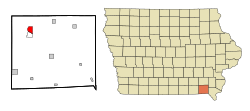
Location of Douds, Iowa
|
|
| Country | |
| State | |
| County | Van Buren |
| Area | |
| • Total | 2.31 sq mi (5.99 km2) |
| • Land | 2.21 sq mi (5.73 km2) |
| • Water | 0.10 sq mi (0.26 km2) |
| Elevation | 604 ft (184 m) |
| Population
(2020)
|
|
| • Total | 156 |
| • Density | 70.52/sq mi (27.23/km2) |
| Time zone | UTC-6 (Central (CST)) |
| • Summer (DST) | UTC-5 (CDT) |
| ZIP code |
52551
|
| Area code(s) | 641 |
| FIPS code | 19-22035 |
| GNIS feature ID | 0455960 |
Douds is a small community in Van Buren County, Iowa, United States. It is a "census-designated place" (CDP), which means it's an area identified for population counting, but it's not an officially incorporated town. In 2020, about 156 people lived there.
Contents
History of Douds
Douds was started in 1866 by two brothers, Eliab and David Doud. It was first called Doud's Station. Even though it was never an official town, Douds has its own Post Office and zip code.
Douds and Leando: Twin Cities
On the south side of the Des Moines River is Leando, which is like Douds' "Twin City." Leando is older but smaller than Douds. It was settled in the 1830s and was originally named Portland. For a long time, Douds and Portland had a friendly rivalry. This changed after the first iron bridge was built in 1898, connecting the two areas. Today, they are considered one community.
Local Businesses and Events
Douds is home to Douds Stone Inc., which runs one of the largest underground limestone mines in Iowa. The Farmers and Traders Savings Bank, founded in 1910, is also in Douds. This bank is special because it was one of the few banks to survive the Great Depression. Every year, Douds hosts its annual Field Day on the last full weekend in June.
Geography of Douds
Douds is located in the northwestern part of Van Buren County. Its exact coordinates are 40.839571 degrees North and -92.085476 degrees West.
Area and Water
According to the United States Census Bureau, Douds covers a total area of about 2.3 square miles (5.99 square kilometers). Most of this area, about 2.2 square miles (5.73 square kilometers), is land. The remaining 0.1 square miles (0.26 square kilometers) is water.
Population of Douds
| Historical population | |||
|---|---|---|---|
| Census | Pop. | %± | |
| 2020 | 156 | — | |
| U.S. Decennial Census | |||
In 2000, there were 165 people living in Douds. The population density was about 74.7 people per square mile.
Age Groups
The population in Douds is spread out across different age groups. In 2000:
- About 21.8% of the people were under 18 years old.
- About 6.1% were between 18 and 24 years old.
- About 22.4% were between 25 and 44 years old.
- About 23.6% were between 45 and 64 years old.
- About 26.1% were 65 years old or older.
The average age in Douds was 45 years.
Education in Douds
The community of Douds is part of the Van Buren County Community School District. This district operates the Douds Elementary Attendance Center, which is located next to the Leando community.
School District Changes
Before July 1, 2019, Douds was part of the former Van Buren Community School District. This district used to operate the school, which was then known as Douds Elementary School. The Van Buren Community School District later merged with another district to form the current Van Buren County Community School District.
Images for kids
See also
 In Spanish: Douds (Iowa) para niños
 | James B. Knighten |
 | Azellia White |
 | Willa Brown |


