Drumkeeragh Forest facts for kids
Quick facts for kids Drumkeeragh Forest |
|
|---|---|
 |
|
| Map | |
| Geography | |
| Location | Down, Northern Ireland, United Kingdom |
| Coordinates | 54°21′06″N 5°56′45″W / 54.351599°N 5.9458209°W |
| Elevation | 190 metres (620 ft) to 310 metres (1,020 ft) |
| Area | 179.81 hectares (444.3 acres) |
| Administration | |
| Governing body | Forest Service Northern Ireland |
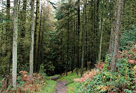
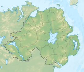
Drumkeeragh Forest is a special woodland found on the lower parts of Slieve Croob mountain. It is located near Ballynahinch in Northern Ireland. This forest is a mix of different types of cone-bearing trees. It is used to grow trees that are later cut down for wood. The Forest Service Northern Ireland looks after the forest.
Contents
What Trees Grow in Drumkeeragh Forest?
Most of the trees in Drumkeeragh Forest are Sitka spruce trees. But you can also find other types of trees there. These include Norway spruce, western red cedar, and European larch. There are also Douglas fir, noble fir, and different kinds of pine trees. Some of these pines are Scots, lodgepole, and Corsican pines.
Why Some Trees Don't Grow Here
The forest is quite high up, between 190 meters and 310 meters above sea level. The soil in the forest is not very rich. Because of this, some types of trees that lose their leaves in autumn, like oak or maple, cannot grow well here. These trees are usually grown for timber in other places.
How the Forest is Managed
The trees in Drumkeeragh Forest are grown to be harvested for timber. This means they are cut down when they are ready. After an area is cleared, new trees are planted. This cycle of growing and cutting trees happens about every 50 years.
Helping Wildlife in the Forest
When new trees are planted in the cleared areas, it is done carefully. The goal is to help wildlife and make the forest look nice. Some of the new trees planted are native broadleaf trees. These include mountain ash and silver birch. Planting these different trees has helped more kinds of birds live in the forest. This makes the forest a better home for many animals.


